You are here: Home > Network List > TO - Tectonic Observatory Stations List
> Station CC31 CCSE CC31 > Earthquake Result Viewer
CC31 CCSE CC31 - Earthquake Result Viewer
| Earthquake location: |
Chiapas, Mexico |
| Earthquake latitude/longitude: |
16.2/-93.6 |
| Earthquake time(UTC): |
2015/08/05 (217) 09:13:24 GMT |
| Earthquake Depth: |
110 km |
| Earthquake Magnitude: |
5.7 MWB |
| Earthquake Catalog/Contributor: |
NEIC PDE/NEIC COMCAT |
|
| Network: |
TO Tectonic Observatory |
| Station: |
CC31 CCSE CC31 |
| Lat/Lon: |
36.32 N/119.27 W |
| Elevation: |
93 m |
|
| Distance: |
30.4 deg |
| Az: |
316.252 deg |
| Baz: |
124.636 deg |
| Ray Param: |
0.07916462 |
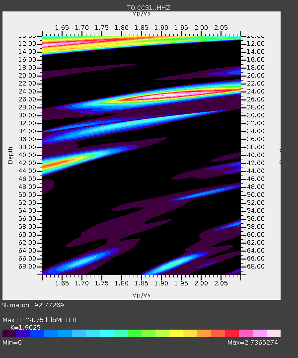
| Estimated Moho Depth: |
24.75 km |
| Estimated Crust Vp/Vs: |
1.90 |
| Assumed Crust Vp: |
6.291 km/s |
| Estimated Crust Vs: |
3.307 km/s |
| Estimated Crust Poisson's Ratio: |
0.31 |
|
| Radial Match: |
92.77269 % |
| Radial Bump: |
367 |
| Transverse Match: |
80.35072 % |
| Transverse Bump: |
400 |
| SOD ConfigId: |
7422571 |
| Insert Time: |
2019-04-20 04:07:04.610 +0000 |
| GWidth: |
2.5 |
| Max Bumps: |
400 |
| Tol: |
0.001 |
|

Signal To Noise
| Channel | StoN | STA | LTA |
| TO:CC31: :HHZ:20150805T09:18:54.260015Z | 34.90845 | 2.3934642E-6 | 6.8564034E-8 |
| TO:CC31: :HHN:20150805T09:18:54.260015Z | 8.332336 | 1.1020353E-6 | 1.3226006E-7 |
| TO:CC31: :HHE:20150805T09:18:54.260015Z | 4.3041964 | 1.0104781E-6 | 2.3476578E-7 |
| Arrivals |
| Ps | 3.8 SECOND |
| PpPs | 11 SECOND |
| PsPs/PpSs | 14 SECOND |


