You are here: Home > Network List > UW - Pacific Northwest Regional Seismic Network Stations List
> Station HOOD Mt Hood Meadows, OR CREST BB SMO > Earthquake Result Viewer
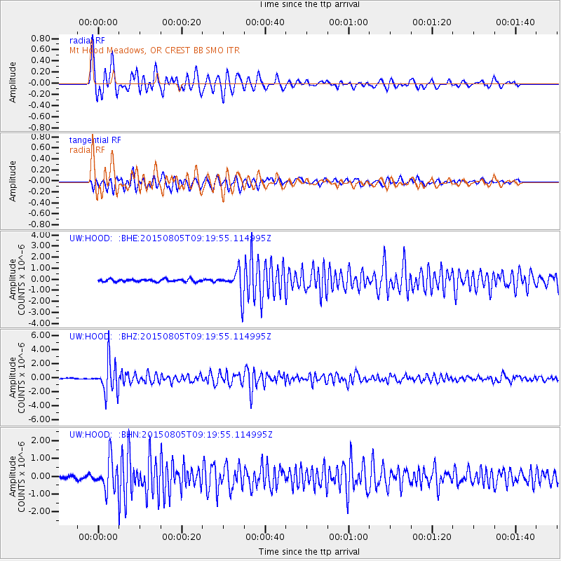
HOOD Mt Hood Meadows, OR CREST BB SMO - Earthquake Result Viewer
*The percent match for this event was below the threshold and hence no stack was calculated.
| Earthquake location: |
Chiapas, Mexico |
| Earthquake latitude/longitude: |
16.2/-93.6 |
| Earthquake time(UTC): |
2015/08/05 (217) 09:13:24 GMT |
| Earthquake Depth: |
110 km |
| Earthquake Magnitude: |
5.7 MWB |
| Earthquake Catalog/Contributor: |
NEIC PDE/NEIC COMCAT |
|
| Network: |
UW Pacific Northwest Regional Seismic Network |
| Station: |
HOOD Mt Hood Meadows, OR CREST BB SMO |
| Lat/Lon: |
45.32 N/121.65 W |
| Elevation: |
1520 m |
|
| Distance: |
37.4 deg |
| Az: |
326.907 deg |
| Baz: |
131.952 deg |
| Ray Param: |
$rayparam |
*The percent match for this event was below the threshold and hence was not used in the summary stack. |
|
| Radial Match: |
93.62493 % |
| Radial Bump: |
400 |
| Transverse Match: |
88.76053 % |
| Transverse Bump: |
400 |
| SOD ConfigId: |
7422571 |
| Insert Time: |
2019-04-20 04:07:27.337 +0000 |
| GWidth: |
2.5 |
| Max Bumps: |
400 |
| Tol: |
0.001 |
|
Signal To Noise
| Channel | StoN | STA | LTA |
| UW:HOOD: :BHZ:20150805T09:19:55.114995Z | 22.560318 | 2.3254706E-6 | 1.03077916E-7 |
| UW:HOOD: :BHN:20150805T09:19:55.114995Z | 9.9725485 | 8.8565463E-7 | 8.880926E-8 |
| UW:HOOD: :BHE:20150805T09:19:55.114995Z | 12.814556 | 1.4318576E-6 | 1.1173682E-7 |
| Arrivals |
| Ps | |
| PpPs | |
| PsPs/PpSs | |


