You are here: Home > Network List > UW - Pacific Northwest Regional Seismic Network Stations List
> Station UMAT Pilot Rock, OR, USA > Earthquake Result Viewer
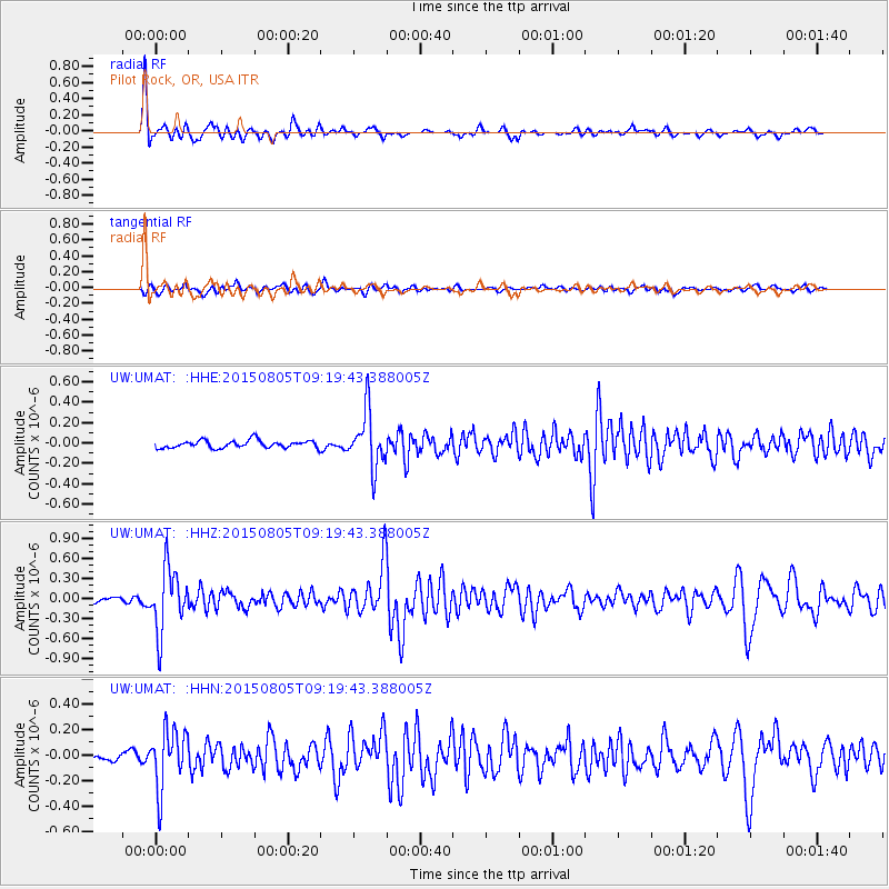
UMAT Pilot Rock, OR, USA - Earthquake Result Viewer
*The percent match for this event was below the threshold and hence no stack was calculated.
| Earthquake location: |
Chiapas, Mexico |
| Earthquake latitude/longitude: |
16.2/-93.6 |
| Earthquake time(UTC): |
2015/08/05 (217) 09:13:24 GMT |
| Earthquake Depth: |
110 km |
| Earthquake Magnitude: |
5.7 MWB |
| Earthquake Catalog/Contributor: |
NEIC PDE/NEIC COMCAT |
|
| Network: |
UW Pacific Northwest Regional Seismic Network |
| Station: |
UMAT Pilot Rock, OR, USA |
| Lat/Lon: |
45.29 N/118.96 W |
| Elevation: |
1318 m |
|
| Distance: |
36.0 deg |
| Az: |
329.07 deg |
| Baz: |
135.595 deg |
| Ray Param: |
$rayparam |
*The percent match for this event was below the threshold and hence was not used in the summary stack. |
|
| Radial Match: |
80.82094 % |
| Radial Bump: |
400 |
| Transverse Match: |
63.748253 % |
| Transverse Bump: |
400 |
| SOD ConfigId: |
7422571 |
| Insert Time: |
2019-04-20 04:07:45.291 +0000 |
| GWidth: |
2.5 |
| Max Bumps: |
400 |
| Tol: |
0.001 |
|
Signal To Noise
| Channel | StoN | STA | LTA |
| UW:UMAT: :HHZ:20150805T09:19:43.388005Z | 8.894811 | 4.7429756E-7 | 5.332295E-8 |
| UW:UMAT: :HHN:20150805T09:19:43.388005Z | 5.5320125 | 2.3479028E-7 | 4.244211E-8 |
| UW:UMAT: :HHE:20150805T09:19:43.388005Z | 7.332039 | 2.7329523E-7 | 3.7274113E-8 |
| Arrivals |
| Ps | |
| PpPs | |
| PsPs/PpSs | |


