You are here: Home > Network List > IU - Global Seismograph Network (GSN - IRIS/USGS) Stations List
> Station PAB San Pablo, Spain > Earthquake Result Viewer
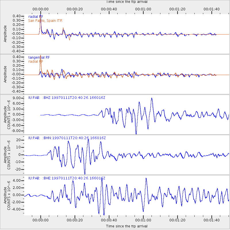
PAB San Pablo, Spain - Earthquake Result Viewer

| Earthquake location: |
Michoacan, Mexico |
| Earthquake latitude/longitude: |
18.2/-102.8 |
| Earthquake time(UTC): |
1997/01/11 (011) 20:28:26 GMT |
| Earthquake Depth: |
33 km |
| Earthquake Magnitude: |
6.5 MB, 6.9 MS, 7.1 UNKNOWN, 7.0 ME |
| Earthquake Catalog/Contributor: |
WHDF/NEIC |
|
| Network: |
IU Global Seismograph Network (GSN - IRIS/USGS) |
| Station: |
PAB San Pablo, Spain |
| Lat/Lon: |
39.55 N/4.35 W |
| Elevation: |
925 m |
|
| Distance: |
84.9 deg |
| Az: |
50.174 deg |
| Baz: |
289.253 deg |
| Ray Param: |
0.045136977 |
| Estimated Moho Depth: |
31.0 km |
| Estimated Crust Vp/Vs: |
1.82 |
| Assumed Crust Vp: |
6.276 km/s |
| Estimated Crust Vs: |
3.458 km/s |
| Estimated Crust Poisson's Ratio: |
0.28 |
|
| Radial Match: |
97.39362 % |
| Radial Bump: |
400 |
| Transverse Match: |
94.41903 % |
| Transverse Bump: |
400 |
| SOD ConfigId: |
4480 |
| Insert Time: |
2010-03-04 14:39:40.541 +0000 |
| GWidth: |
2.5 |
| Max Bumps: |
400 |
| Tol: |
0.001 |
|
Signal To Noise
| Channel | StoN | STA | LTA |
| IU:PAB: :BHN:19970111T20:40:26.166016Z | 4.8495846 | 1.2668903E-6 | 2.6123686E-7 |
| IU:PAB: :BHE:19970111T20:40:26.166016Z | 1.7396029 | 2.697033E-7 | 1.5503727E-7 |
| IU:PAB: :BHZ:19970111T20:40:26.166016Z | 2.1710334 | 3.830704E-7 | 1.764461E-7 |
| Arrivals |
| Ps | 4.1 SECOND |
| PpPs | 14 SECOND |
| PsPs/PpSs | 18 SECOND |


