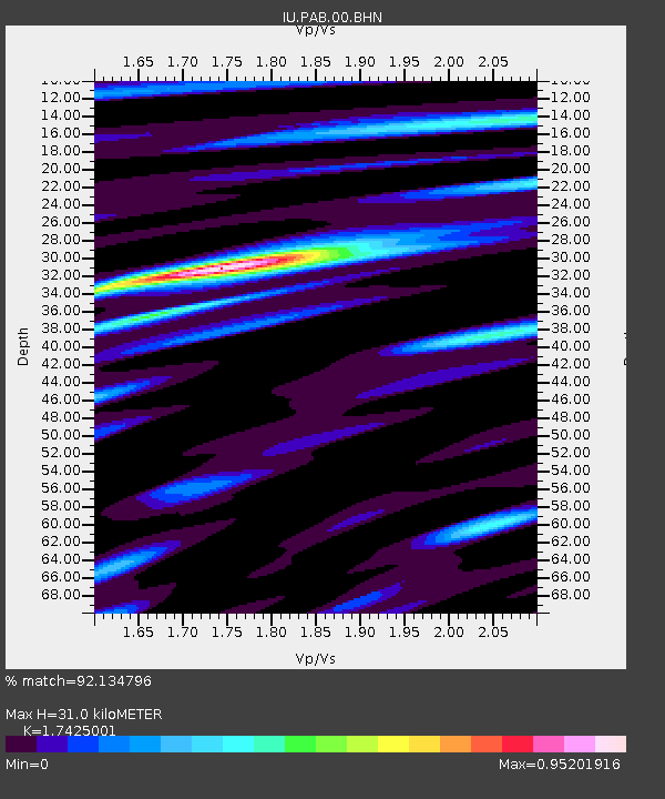
PAB San Pablo, Spain - Earthquake Result Viewer
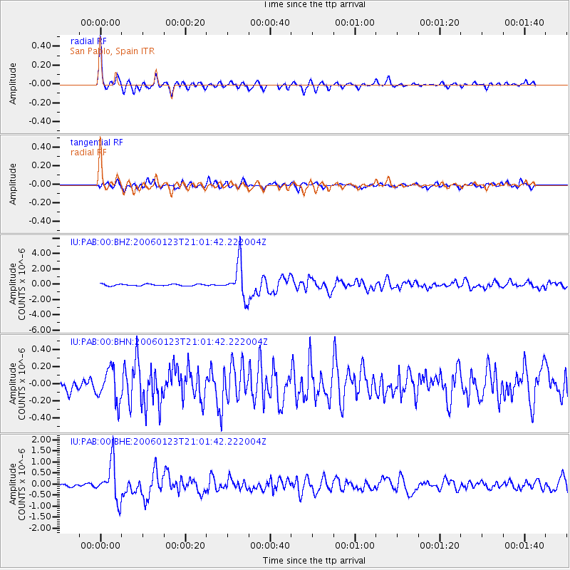
Earthquake location: Near West Coast Of Colombia
Earthquake latitude/longitude: 6.9/-77.8
Earthquake time(UTC): 2006/01/23 (023) 20:50:44 GMT
Earthquake Depth: 14 km
Earthquake Magnitude: 6.1 MB, 5.9 MS, 6.2 MW, 6.1 MW
Earthquake Catalog/Contributor: WHDF/NEIC
Network: IU Global Seismograph Network (GSN - IRIS/USGS)
Station: PAB San Pablo, Spain
Lat/Lon: 39.55 N/4.35 W
Elevation: 925 m
Distance: 72.9 deg
Az: 50.845 deg
Baz: 264.74 deg
Ray Param: 0.053349912
Estimated Moho Depth: 31.0 km
Estimated Crust Vp/Vs: 1.74
Assumed Crust Vp: 6.276 km/s
Estimated Crust Vs: 3.602 km/s
Estimated Crust Poisson's Ratio: 0.25
Radial Match: 92.134796 %
Radial Bump: 359
Transverse Match: 75.94853 %
Transverse Bump: 400
SOD ConfigId: 4977
Insert Time: 2010-03-04 14:39:51.718 +0000
GWidth: 2.5
Max Bumps: 400
Tol: 0.001

Signal To Noise

ChannelStoNSTALTA
IU:PAB:00:BHN:20060123T21:01:42.222004Z2.10618731.9499639E-79.2582646E-8
IU:PAB:00:BHE:20060123T21:01:42.222004Z14.9618.7518663E-75.8497868E-8
IU:PAB:00:BHZ:20060123T21:01:42.222004Z22.3976922.3616265E-61.0544061E-7
Arrivals
Ps3.8 SECOND
PpPs13 SECOND
PsPs/PpSs17 SECOND