You are here: Home > Network List > CI - Caltech Regional Seismic Network Stations List
> Station GLA Glamis, California, USA > Earthquake Result Viewer
GLA Glamis, California, USA - Earthquake Result Viewer
| Earthquake location: |
Off Coast Of Central America |
| Earthquake latitude/longitude: |
11.7/-88.0 |
| Earthquake time(UTC): |
1998/08/23 (235) 13:57:15 GMT |
| Earthquake Depth: |
55 km |
| Earthquake Magnitude: |
5.7 MB, 6.3 MS, 6.8 UNKNOWN, 6.7 MW |
| Earthquake Catalog/Contributor: |
WHDF/NEIC |
|
| Network: |
CI Caltech Regional Seismic Network |
| Station: |
GLA Glamis, California, USA |
| Lat/Lon: |
33.05 N/114.83 W |
| Elevation: |
627 m |
|
| Distance: |
32.5 deg |
| Az: |
315.2 deg |
| Baz: |
124.725 deg |
| Ray Param: |
0.07851086 |
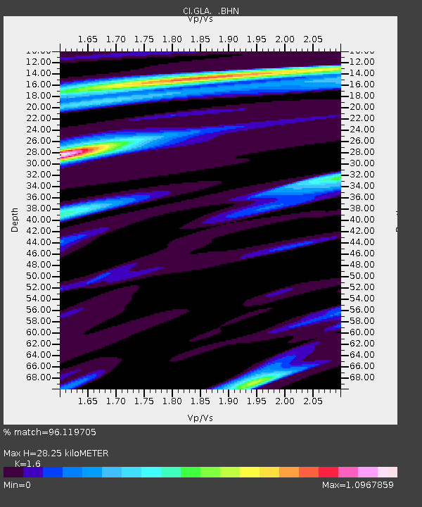
| Estimated Moho Depth: |
28.25 km |
| Estimated Crust Vp/Vs: |
1.60 |
| Assumed Crust Vp: |
6.155 km/s |
| Estimated Crust Vs: |
3.847 km/s |
| Estimated Crust Poisson's Ratio: |
0.18 |
|
| Radial Match: |
96.119705 % |
| Radial Bump: |
386 |
| Transverse Match: |
87.8759 % |
| Transverse Bump: |
400 |
| SOD ConfigId: |
3787 |
| Insert Time: |
2010-02-25 21:47:50.214 +0000 |
| GWidth: |
2.5 |
| Max Bumps: |
400 |
| Tol: |
0.001 |
|
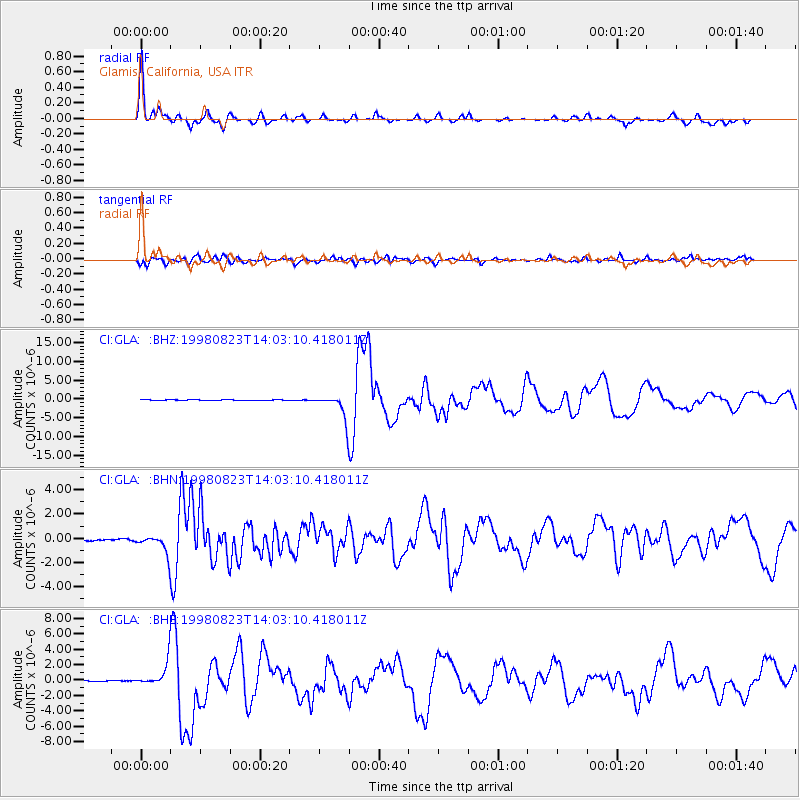
Signal To Noise
| Channel | StoN | STA | LTA |
| CI:GLA: :BHN:19980823T14:03:10.418011Z | 9.514038 | 7.446335E-7 | 7.8266815E-8 |
| CI:GLA: :BHE:19980823T14:03:10.418011Z | 21.860722 | 1.5216647E-6 | 6.960725E-8 |
| CI:GLA: :BHZ:19980823T14:03:10.418011Z | 55.794758 | 3.2952921E-6 | 5.9060962E-8 |
| Arrivals |
| Ps | 3.0 SECOND |
| PpPs | 11 SECOND |
| PsPs/PpSs | 14 SECOND |


