You are here: Home > Network List > GS - US Geological Survey Networks Stations List
> Station KAN10 Keim Farm > Earthquake Result Viewer
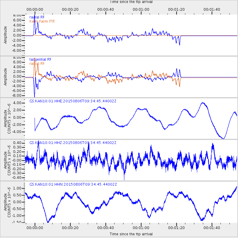
KAN10 Keim Farm - Earthquake Result Viewer
*The percent match for this event was below the threshold and hence no stack was calculated.
| Earthquake location: |
Near East Coast Of Honshu, Japan |
| Earthquake latitude/longitude: |
36.5/140.6 |
| Earthquake time(UTC): |
2015/08/06 (218) 09:22:28 GMT |
| Earthquake Depth: |
56 km |
| Earthquake Magnitude: |
5.2 MW |
| Earthquake Catalog/Contributor: |
ISC/ISC |
|
| Network: |
GS US Geological Survey Networks |
| Station: |
KAN10 Keim Farm |
| Lat/Lon: |
37.12 N/98.10 W |
| Elevation: |
417 m |
|
| Distance: |
88.8 deg |
| Az: |
43.105 deg |
| Baz: |
316.428 deg |
| Ray Param: |
$rayparam |
*The percent match for this event was below the threshold and hence was not used in the summary stack. |
|
| Radial Match: |
59.274265 % |
| Radial Bump: |
263 |
| Transverse Match: |
64.613335 % |
| Transverse Bump: |
331 |
| SOD ConfigId: |
7422571 |
| Insert Time: |
2019-04-20 04:26:04.571 +0000 |
| GWidth: |
2.5 |
| Max Bumps: |
400 |
| Tol: |
0.001 |
|
Signal To Noise
| Channel | StoN | STA | LTA |
| GS:KAN10:01:HHZ:20150806T09:34:45.44002Z | 1.8924351 | 1.8897381E-7 | 9.985749E-8 |
| GS:KAN10:01:HHN:20150806T09:34:45.44002Z | 0.81785077 | 3.6494262E-7 | 4.4622152E-7 |
| GS:KAN10:01:HHE:20150806T09:34:45.44002Z | 1.8263525 | 2.344449E-6 | 1.2836784E-6 |
| Arrivals |
| Ps | |
| PpPs | |
| PsPs/PpSs | |


