You are here: Home > Network List > CI - Caltech Regional Seismic Network Stations List
> Station GLA Glamis, California, USA > Earthquake Result Viewer
GLA Glamis, California, USA - Earthquake Result Viewer
| Earthquake location: |
Santa Cruz Islands |
| Earthquake latitude/longitude: |
-11.0/166.2 |
| Earthquake time(UTC): |
1998/07/16 (197) 11:56:36 GMT |
| Earthquake Depth: |
110 km |
| Earthquake Magnitude: |
6.4 MB, 6.7 MS, 7.1 UNKNOWN, 6.9 ME |
| Earthquake Catalog/Contributor: |
WHDF/NEIC |
|
| Network: |
CI Caltech Regional Seismic Network |
| Station: |
GLA Glamis, California, USA |
| Lat/Lon: |
33.05 N/114.83 W |
| Elevation: |
627 m |
|
| Distance: |
86.9 deg |
| Az: |
55.654 deg |
| Baz: |
254.827 deg |
| Ray Param: |
0.043469697 |
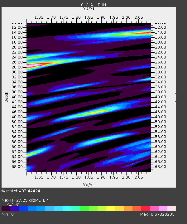
| Estimated Moho Depth: |
27.25 km |
| Estimated Crust Vp/Vs: |
1.61 |
| Assumed Crust Vp: |
6.155 km/s |
| Estimated Crust Vs: |
3.823 km/s |
| Estimated Crust Poisson's Ratio: |
0.19 |
|
| Radial Match: |
97.44424 % |
| Radial Bump: |
400 |
| Transverse Match: |
90.52513 % |
| Transverse Bump: |
400 |
| SOD ConfigId: |
4770 |
| Insert Time: |
2010-02-25 21:47:56.215 +0000 |
| GWidth: |
2.5 |
| Max Bumps: |
400 |
| Tol: |
0.001 |
|
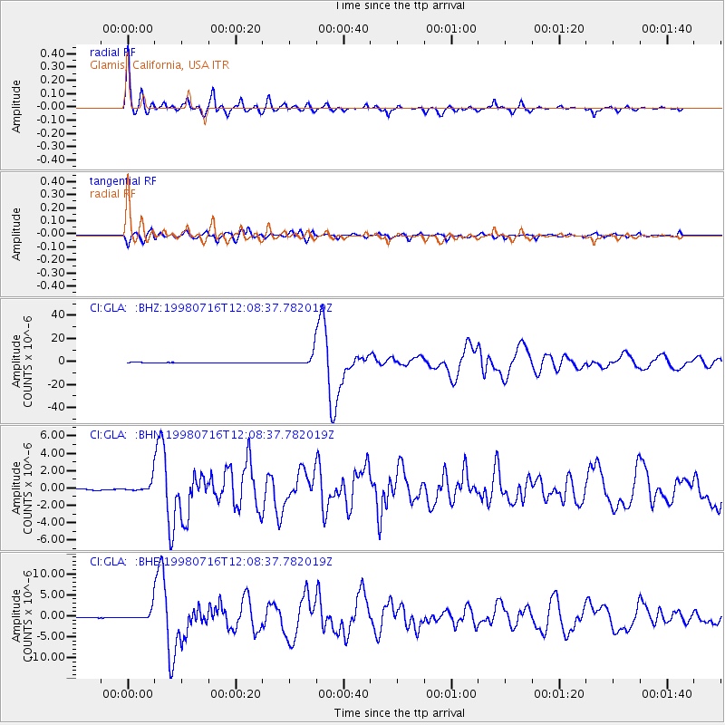
Signal To Noise
| Channel | StoN | STA | LTA |
| CI:GLA: :BHN:19980716T12:08:37.782019Z | 9.254234 | 6.571137E-7 | 7.1006816E-8 |
| CI:GLA: :BHE:19980716T12:08:37.782019Z | 19.431618 | 1.3685766E-6 | 7.0430396E-8 |
| CI:GLA: :BHZ:19980716T12:08:37.782019Z | 36.04153 | 5.893416E-6 | 1.6351736E-7 |
| Arrivals |
| Ps | 2.8 SECOND |
| PpPs | 11 SECOND |
| PsPs/PpSs | 14 SECOND |


