You are here: Home > Network List > TA - USArray Transportable Network (new EarthScope stations) Stations List
> Station 121A Cookes Peak, Deming, NM, USA > Earthquake Result Viewer
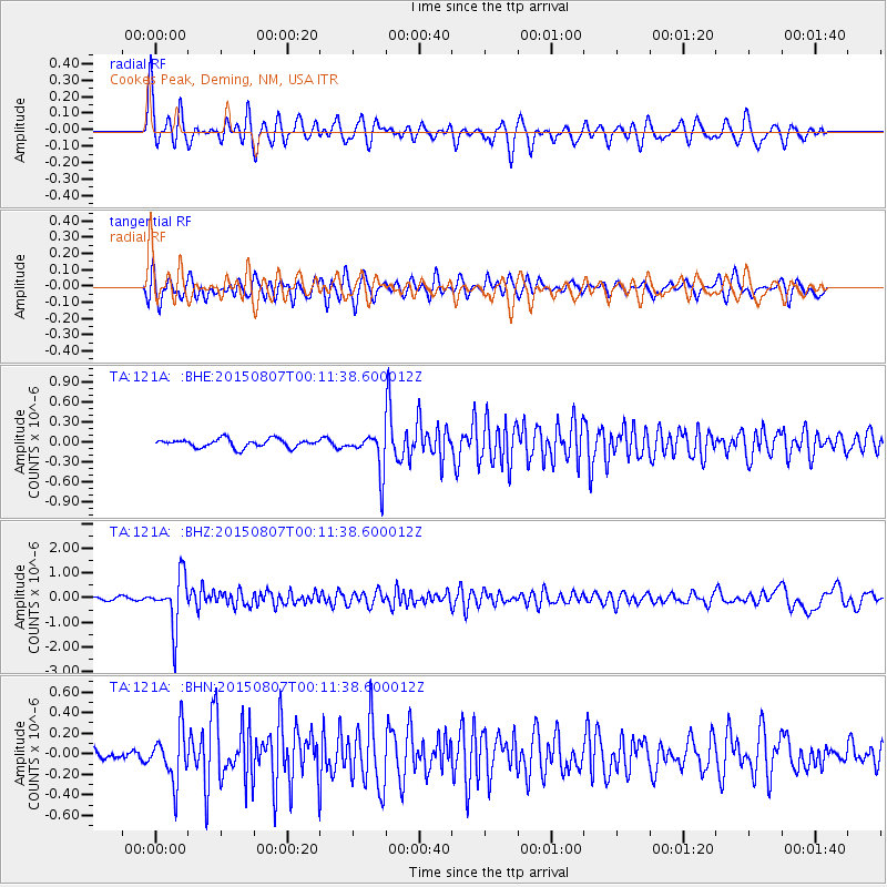
121A Cookes Peak, Deming, NM, USA - Earthquake Result Viewer
*The percent match for this event was below the threshold and hence no stack was calculated.
| Earthquake location: |
South Of Fiji Islands |
| Earthquake latitude/longitude: |
-26.5/-178.3 |
| Earthquake time(UTC): |
2015/08/06 (218) 23:59:45 GMT |
| Earthquake Depth: |
264 km |
| Earthquake Magnitude: |
5.9 MB |
| Earthquake Catalog/Contributor: |
NEIC PDE/NEIC ALERT |
|
| Network: |
TA USArray Transportable Network (new EarthScope stations) |
| Station: |
121A Cookes Peak, Deming, NM, USA |
| Lat/Lon: |
32.53 N/107.79 W |
| Elevation: |
1652 m |
|
| Distance: |
89.1 deg |
| Az: |
52.79 deg |
| Baz: |
237.679 deg |
| Ray Param: |
$rayparam |
*The percent match for this event was below the threshold and hence was not used in the summary stack. |
|
| Radial Match: |
75.357735 % |
| Radial Bump: |
400 |
| Transverse Match: |
70.85183 % |
| Transverse Bump: |
400 |
| SOD ConfigId: |
7422571 |
| Insert Time: |
2019-04-20 04:39:15.062 +0000 |
| GWidth: |
2.5 |
| Max Bumps: |
400 |
| Tol: |
0.001 |
|
Signal To Noise
| Channel | StoN | STA | LTA |
| TA:121A: :BHZ:20150807T00:11:38.600012Z | 11.871273 | 1.021248E-6 | 8.602683E-8 |
| TA:121A: :BHN:20150807T00:11:38.600012Z | 4.4193487 | 2.45106E-7 | 5.5462024E-8 |
| TA:121A: :BHE:20150807T00:11:38.600012Z | 6.723349 | 4.4239113E-7 | 6.579922E-8 |
| Arrivals |
| Ps | |
| PpPs | |
| PsPs/PpSs | |


