You are here: Home > Network List > TA - USArray Transportable Network (new EarthScope stations) Stations List
> Station A04D Lummi Island, WA, USA > Earthquake Result Viewer
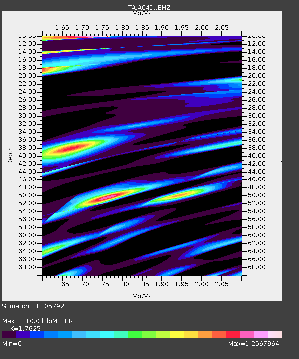
A04D Lummi Island, WA, USA - Earthquake Result Viewer
| Earthquake location: |
South Of Fiji Islands |
| Earthquake latitude/longitude: |
-26.5/-178.3 |
| Earthquake time(UTC): |
2015/08/06 (218) 23:59:45 GMT |
| Earthquake Depth: |
264 km |
| Earthquake Magnitude: |
5.9 MB |
| Earthquake Catalog/Contributor: |
NEIC PDE/NEIC ALERT |
|
| Network: |
TA USArray Transportable Network (new EarthScope stations) |
| Station: |
A04D Lummi Island, WA, USA |
| Lat/Lon: |
48.72 N/122.71 W |
| Elevation: |
13 m |
|
| Distance: |
89.8 deg |
| Az: |
33.119 deg |
| Baz: |
227.689 deg |
| Ray Param: |
0.041657038 |
| Estimated Moho Depth: |
10.0 km |
| Estimated Crust Vp/Vs: |
1.76 |
| Assumed Crust Vp: |
6.566 km/s |
| Estimated Crust Vs: |
3.725 km/s |
| Estimated Crust Poisson's Ratio: |
0.26 |
|
| Radial Match: |
81.05792 % |
| Radial Bump: |
400 |
| Transverse Match: |
73.8367 % |
| Transverse Bump: |
400 |
| SOD ConfigId: |
7422571 |
| Insert Time: |
2019-04-20 04:39:15.344 +0000 |
| GWidth: |
2.5 |
| Max Bumps: |
400 |
| Tol: |
0.001 |
|

Signal To Noise
| Channel | StoN | STA | LTA |
| TA:A04D: :BHZ:20150807T00:11:41.949988Z | 35.13928 | 2.3471716E-6 | 6.679624E-8 |
| TA:A04D: :BHN:20150807T00:11:41.949988Z | 8.354314 | 7.6652697E-7 | 9.175223E-8 |
| TA:A04D: :BHE:20150807T00:11:41.949988Z | 5.1204405 | 5.082866E-7 | 9.926618E-8 |
| Arrivals |
| Ps | 1.2 SECOND |
| PpPs | 4.1 SECOND |
| PsPs/PpSs | 5.3 SECOND |


