You are here: Home > Network List > UW - Pacific Northwest Regional Seismic Network Stations List
> Station LEBA Lebam, WA, USA > Earthquake Result Viewer
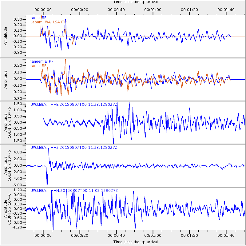
LEBA Lebam, WA, USA - Earthquake Result Viewer
*The percent match for this event was below the threshold and hence no stack was calculated.
| Earthquake location: |
South Of Fiji Islands |
| Earthquake latitude/longitude: |
-26.5/-178.3 |
| Earthquake time(UTC): |
2015/08/06 (218) 23:59:45 GMT |
| Earthquake Depth: |
264 km |
| Earthquake Magnitude: |
5.9 MB |
| Earthquake Catalog/Contributor: |
NEIC PDE/NEIC ALERT |
|
| Network: |
UW Pacific Northwest Regional Seismic Network |
| Station: |
LEBA Lebam, WA, USA |
| Lat/Lon: |
46.55 N/123.56 W |
| Elevation: |
73 m |
|
| Distance: |
87.9 deg |
| Az: |
34.327 deg |
| Baz: |
227.081 deg |
| Ray Param: |
$rayparam |
*The percent match for this event was below the threshold and hence was not used in the summary stack. |
|
| Radial Match: |
86.02055 % |
| Radial Bump: |
400 |
| Transverse Match: |
81.2967 % |
| Transverse Bump: |
400 |
| SOD ConfigId: |
7422571 |
| Insert Time: |
2019-04-20 04:41:13.775 +0000 |
| GWidth: |
2.5 |
| Max Bumps: |
400 |
| Tol: |
0.001 |
|
Signal To Noise
| Channel | StoN | STA | LTA |
| UW:LEBA: :HHZ:20150807T00:11:33.128027Z | 24.576878 | 2.2468448E-6 | 9.142108E-8 |
| UW:LEBA: :HHN:20150807T00:11:33.128027Z | 3.5877151 | 4.257359E-7 | 1.18664914E-7 |
| UW:LEBA: :HHE:20150807T00:11:33.128027Z | 2.6453195 | 3.8332502E-7 | 1.4490689E-7 |
| Arrivals |
| Ps | |
| PpPs | |
| PsPs/PpSs | |


