You are here: Home > Network List > UW - Pacific Northwest Regional Seismic Network Stations List
> Station PASS Maple Falls, WA, USA > Earthquake Result Viewer
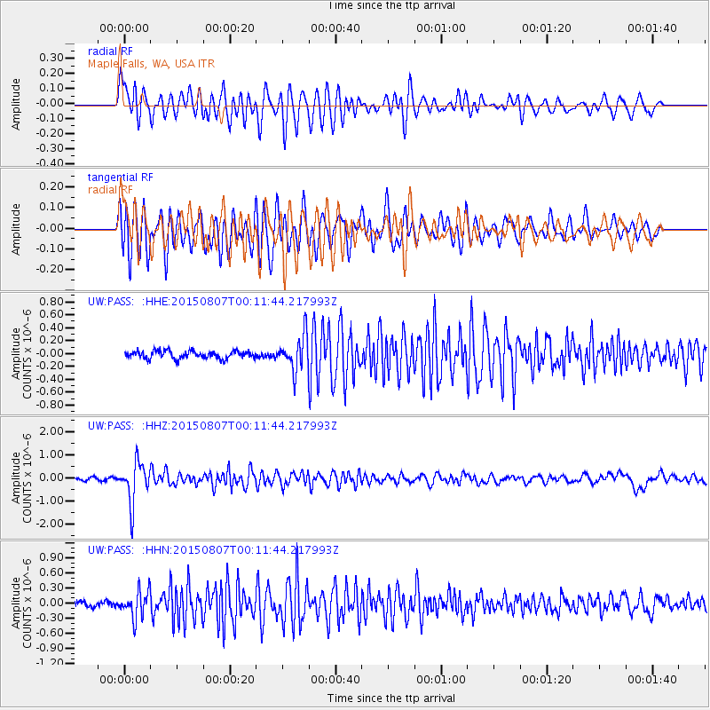
PASS Maple Falls, WA, USA - Earthquake Result Viewer
*The percent match for this event was below the threshold and hence no stack was calculated.
| Earthquake location: |
South Of Fiji Islands |
| Earthquake latitude/longitude: |
-26.5/-178.3 |
| Earthquake time(UTC): |
2015/08/06 (218) 23:59:45 GMT |
| Earthquake Depth: |
264 km |
| Earthquake Magnitude: |
5.9 MB |
| Earthquake Catalog/Contributor: |
NEIC PDE/NEIC ALERT |
|
| Network: |
UW Pacific Northwest Regional Seismic Network |
| Station: |
PASS Maple Falls, WA, USA |
| Lat/Lon: |
49.00 N/122.09 W |
| Elevation: |
174 m |
|
| Distance: |
90.3 deg |
| Az: |
33.187 deg |
| Baz: |
228.155 deg |
| Ray Param: |
$rayparam |
*The percent match for this event was below the threshold and hence was not used in the summary stack. |
|
| Radial Match: |
69.401886 % |
| Radial Bump: |
400 |
| Transverse Match: |
74.1487 % |
| Transverse Bump: |
400 |
| SOD ConfigId: |
7422571 |
| Insert Time: |
2019-04-20 04:41:17.167 +0000 |
| GWidth: |
2.5 |
| Max Bumps: |
400 |
| Tol: |
0.001 |
|
Signal To Noise
| Channel | StoN | STA | LTA |
| UW:PASS: :HHZ:20150807T00:11:44.217993Z | 12.474523 | 8.857022E-7 | 7.100089E-8 |
| UW:PASS: :HHN:20150807T00:11:44.217993Z | 4.5721264 | 2.6660078E-7 | 5.831002E-8 |
| UW:PASS: :HHE:20150807T00:11:44.217993Z | 6.0153537 | 3.482873E-7 | 5.7899722E-8 |
| Arrivals |
| Ps | |
| PpPs | |
| PsPs/PpSs | |


