You are here: Home > Network List > XD14 - Illuminating the architecture of the greater Mount St. Helens magmatic systems f Stations List
> Station MO06 "Mount St Helens, WA" > Earthquake Result Viewer
MO06 "Mount St Helens, WA" - Earthquake Result Viewer
| Earthquake location: |
South Of Fiji Islands |
| Earthquake latitude/longitude: |
-26.5/-178.3 |
| Earthquake time(UTC): |
2015/08/06 (218) 23:59:45 GMT |
| Earthquake Depth: |
264 km |
| Earthquake Magnitude: |
5.9 MB |
| Earthquake Catalog/Contributor: |
NEIC PDE/NEIC ALERT |
|
| Network: |
XD Illuminating the architecture of the greater Mount St. Helens magmatic systems f |
| Station: |
MO06 "Mount St Helens, WA" |
| Lat/Lon: |
45.93 N/122.21 W |
| Elevation: |
784 m |
|
| Distance: |
88.2 deg |
| Az: |
35.417 deg |
| Baz: |
228.095 deg |
| Ray Param: |
0.04212583 |
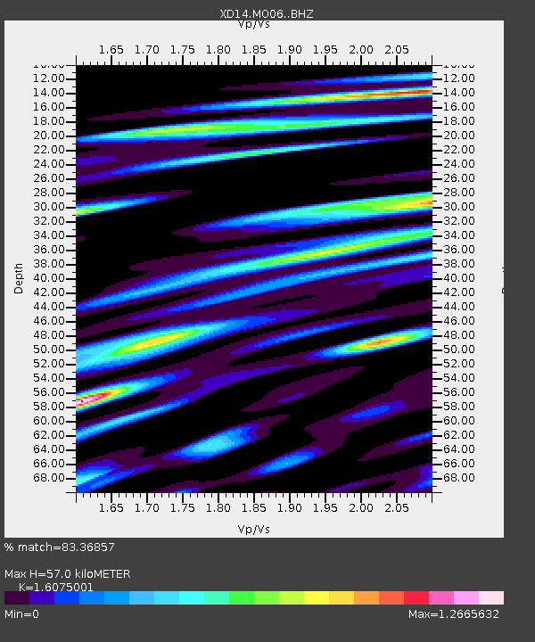
| Estimated Moho Depth: |
57.0 km |
| Estimated Crust Vp/Vs: |
1.61 |
| Assumed Crust Vp: |
6.566 km/s |
| Estimated Crust Vs: |
4.085 km/s |
| Estimated Crust Poisson's Ratio: |
0.18 |
|
| Radial Match: |
83.36857 % |
| Radial Bump: |
335 |
| Transverse Match: |
68.43764 % |
| Transverse Bump: |
400 |
| SOD ConfigId: |
7422571 |
| Insert Time: |
2019-04-20 04:42:14.904 +0000 |
| GWidth: |
2.5 |
| Max Bumps: |
400 |
| Tol: |
0.001 |
|

Signal To Noise
| Channel | StoN | STA | LTA |
| XD:MO06: :BHZ:20150807T00:11:34.449988Z | 27.047863 | 1.570783E-6 | 5.80742E-8 |
| XD:MO06: :BHN:20150807T00:11:34.449988Z | 5.276166 | 5.117761E-7 | 9.6997724E-8 |
| XD:MO06: :BHE:20150807T00:11:34.449988Z | 8.072776 | 7.4152507E-7 | 9.1855036E-8 |
| Arrivals |
| Ps | 5.4 SECOND |
| PpPs | 22 SECOND |
| PsPs/PpSs | 27 SECOND |


