You are here: Home > Network List > YN10 - San Jacinto Fault Zone Stations List
> Station JFN4 JFN4 > Earthquake Result Viewer
JFN4 JFN4 - Earthquake Result Viewer
| Earthquake location: |
South Of Fiji Islands |
| Earthquake latitude/longitude: |
-26.5/-178.3 |
| Earthquake time(UTC): |
2015/08/06 (218) 23:59:45 GMT |
| Earthquake Depth: |
264 km |
| Earthquake Magnitude: |
5.9 MB |
| Earthquake Catalog/Contributor: |
NEIC PDE/NEIC ALERT |
|
| Network: |
YN San Jacinto Fault Zone |
| Station: |
JFN4 JFN4 |
| Lat/Lon: |
33.42 N/116.40 W |
| Elevation: |
646 m |
|
| Distance: |
83.7 deg |
| Az: |
47.921 deg |
| Baz: |
232.7 deg |
| Ray Param: |
0.045351688 |
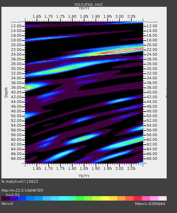
| Estimated Moho Depth: |
22.0 km |
| Estimated Crust Vp/Vs: |
2.03 |
| Assumed Crust Vp: |
6.264 km/s |
| Estimated Crust Vs: |
3.086 km/s |
| Estimated Crust Poisson's Ratio: |
0.34 |
|
| Radial Match: |
87.10623 % |
| Radial Bump: |
400 |
| Transverse Match: |
76.833 % |
| Transverse Bump: |
400 |
| SOD ConfigId: |
7422571 |
| Insert Time: |
2019-04-20 04:42:25.826 +0000 |
| GWidth: |
2.5 |
| Max Bumps: |
400 |
| Tol: |
0.001 |
|

Signal To Noise
| Channel | StoN | STA | LTA |
| YN:JFN4: :HHZ:20150807T00:11:12.464026Z | 17.259138 | 1.8805496E-6 | 1.0895964E-7 |
| YN:JFN4: :HHN:20150807T00:11:12.464026Z | 5.3894815 | 4.1868424E-7 | 7.768544E-8 |
| YN:JFN4: :HHE:20150807T00:11:12.464026Z | 4.082159 | 4.842519E-7 | 1.1862643E-7 |
| Arrivals |
| Ps | 3.7 SECOND |
| PpPs | 10 SECOND |
| PsPs/PpSs | 14 SECOND |


