You are here: Home > Network List > IC - New China Digital Seismograph Network Stations List
> Station KMI Kunming, Yunnan Province, China > Earthquake Result Viewer
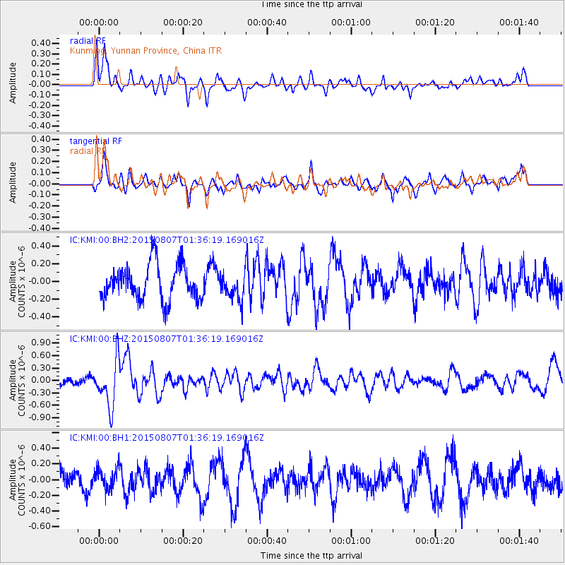
KMI Kunming, Yunnan Province, China - Earthquake Result Viewer
*The percent match for this event was below the threshold and hence no stack was calculated.
| Earthquake location: |
Lake Tanganyika Region |
| Earthquake latitude/longitude: |
-2.2/28.9 |
| Earthquake time(UTC): |
2015/08/07 (219) 01:25:02 GMT |
| Earthquake Depth: |
10 km |
| Earthquake Magnitude: |
5.6 MB |
| Earthquake Catalog/Contributor: |
NEIC PDE/NEIC COMCAT |
|
| Network: |
IC New China Digital Seismograph Network |
| Station: |
KMI Kunming, Yunnan Province, China |
| Lat/Lon: |
25.12 N/102.74 E |
| Elevation: |
1975 m |
|
| Distance: |
76.3 deg |
| Az: |
63.645 deg |
| Baz: |
261.043 deg |
| Ray Param: |
$rayparam |
*The percent match for this event was below the threshold and hence was not used in the summary stack. |
|
| Radial Match: |
53.6452 % |
| Radial Bump: |
400 |
| Transverse Match: |
50.55717 % |
| Transverse Bump: |
400 |
| SOD ConfigId: |
7422571 |
| Insert Time: |
2019-04-20 04:44:47.381 +0000 |
| GWidth: |
2.5 |
| Max Bumps: |
400 |
| Tol: |
0.001 |
|
Signal To Noise
| Channel | StoN | STA | LTA |
| IC:KMI:00:BHZ:20150807T01:36:19.169016Z | 2.8858783 | 5.820592E-7 | 2.0169222E-7 |
| IC:KMI:00:BH1:20150807T01:36:19.169016Z | 0.77210116 | 1.343626E-7 | 1.74022E-7 |
| IC:KMI:00:BH2:20150807T01:36:19.169016Z | 0.9370579 | 1.8597146E-7 | 1.9846314E-7 |
| Arrivals |
| Ps | |
| PpPs | |
| PsPs/PpSs | |


