You are here: Home > Network List > KN - Kyrgyz Seismic Telemetry Network Stations List
> Station CHM KN.CHM > Earthquake Result Viewer
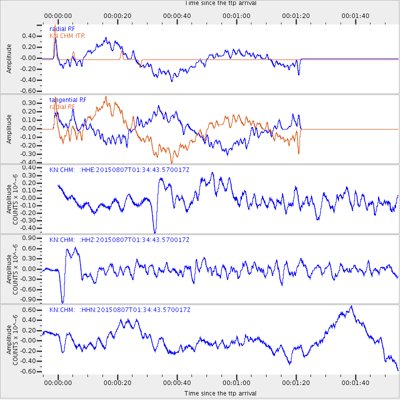
CHM KN.CHM - Earthquake Result Viewer
*The percent match for this event was below the threshold and hence no stack was calculated.
| Earthquake location: |
Lake Tanganyika Region |
| Earthquake latitude/longitude: |
-2.2/28.9 |
| Earthquake time(UTC): |
2015/08/07 (219) 01:25:02 GMT |
| Earthquake Depth: |
10 km |
| Earthquake Magnitude: |
5.6 MB |
| Earthquake Catalog/Contributor: |
NEIC PDE/NEIC COMCAT |
|
| Network: |
KN Kyrgyz Seismic Telemetry Network |
| Station: |
CHM KN.CHM |
| Lat/Lon: |
43.00 N/74.75 E |
| Elevation: |
655 m |
|
| Distance: |
61.0 deg |
| Az: |
37.021 deg |
| Baz: |
235.098 deg |
| Ray Param: |
$rayparam |
*The percent match for this event was below the threshold and hence was not used in the summary stack. |
|
| Radial Match: |
40.11566 % |
| Radial Bump: |
400 |
| Transverse Match: |
22.507801 % |
| Transverse Bump: |
400 |
| SOD ConfigId: |
7422571 |
| Insert Time: |
2019-04-20 04:45:05.018 +0000 |
| GWidth: |
2.5 |
| Max Bumps: |
400 |
| Tol: |
0.001 |
|
Signal To Noise
| Channel | StoN | STA | LTA |
| KN:CHM: :HHZ:20150807T01:34:43.570017Z | 9.888853 | 5.0341146E-7 | 5.0906962E-8 |
| KN:CHM: :HHN:20150807T01:34:43.570017Z | 1.1582158 | 1.979692E-7 | 1.7092601E-7 |
| KN:CHM: :HHE:20150807T01:34:43.570017Z | 3.267777 | 2.399358E-7 | 7.342478E-8 |
| Arrivals |
| Ps | |
| PpPs | |
| PsPs/PpSs | |


