You are here: Home > Network List > IU - Global Seismograph Network (GSN - IRIS/USGS) Stations List
> Station KIP Kipapa, Hawaii, USA > Earthquake Result Viewer
KIP Kipapa, Hawaii, USA - Earthquake Result Viewer
| Earthquake location: |
Vanuatu Islands |
| Earthquake latitude/longitude: |
-13.0/166.5 |
| Earthquake time(UTC): |
2009/10/07 (280) 22:03:14 GMT |
| Earthquake Depth: |
45 km |
| Earthquake Magnitude: |
6.4 MB, 7.3 MS, 7.6 MW, 7.7 MW |
| Earthquake Catalog/Contributor: |
WHDF/NEIC |
|
| Network: |
IU Global Seismograph Network (GSN - IRIS/USGS) |
| Station: |
KIP Kipapa, Hawaii, USA |
| Lat/Lon: |
21.42 N/158.01 W |
| Elevation: |
110 m |
|
| Distance: |
48.8 deg |
| Az: |
45.928 deg |
| Baz: |
228.725 deg |
| Ray Param: |
0.06899006 |
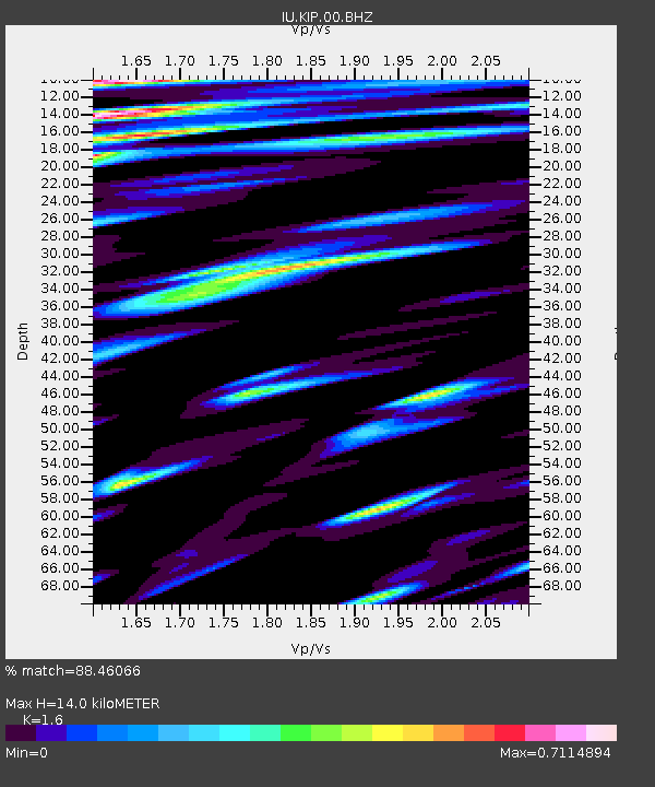
| Estimated Moho Depth: |
14.0 km |
| Estimated Crust Vp/Vs: |
1.60 |
| Assumed Crust Vp: |
4.24 km/s |
| Estimated Crust Vs: |
2.65 km/s |
| Estimated Crust Poisson's Ratio: |
0.18 |
|
| Radial Match: |
88.46066 % |
| Radial Bump: |
361 |
| Transverse Match: |
58.107033 % |
| Transverse Bump: |
400 |
| SOD ConfigId: |
1 |
| Insert Time: |
2010-02-19 00:35:03.645 +0000 |
| GWidth: |
2.5 |
| Max Bumps: |
400 |
| Tol: |
0.001 |
|
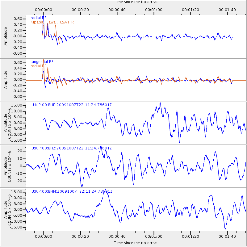
Signal To Noise
| Channel | StoN | STA | LTA |
| IU:KIP:00:BHZ:20091007T22:11:24.78601Z | 2.0543404 | 9.13597E-6 | 4.447155E-6 |
| IU:KIP:00:BHN:20091007T22:11:24.78601Z | 1.1626732 | 2.4094982E-6 | 2.0723778E-6 |
| IU:KIP:00:BHE:20091007T22:11:24.78601Z | 1.777022 | 4.0359837E-6 | 2.2712063E-6 |
| Arrivals |
| Ps | 2.0 SECOND |
| PpPs | 8.4 SECOND |
| PsPs/PpSs | 10 SECOND |


