You are here: Home > Network List > PM - Portuguese National Seismic Network Stations List
> Station PESTR ESTREMOZ, PORTUGAL > Earthquake Result Viewer
PESTR ESTREMOZ, PORTUGAL - Earthquake Result Viewer
| Earthquake location: |
Lake Tanganyika Region |
| Earthquake latitude/longitude: |
-2.2/28.9 |
| Earthquake time(UTC): |
2015/08/07 (219) 01:25:02 GMT |
| Earthquake Depth: |
10 km |
| Earthquake Magnitude: |
5.6 MB |
| Earthquake Catalog/Contributor: |
NEIC PDE/NEIC COMCAT |
|
| Network: |
PM Portuguese National Seismic Network |
| Station: |
PESTR ESTREMOZ, PORTUGAL |
| Lat/Lon: |
38.87 N/7.59 W |
| Elevation: |
410 m |
|
| Distance: |
52.9 deg |
| Az: |
324.39 deg |
| Baz: |
131.812 deg |
| Ray Param: |
0.066492535 |
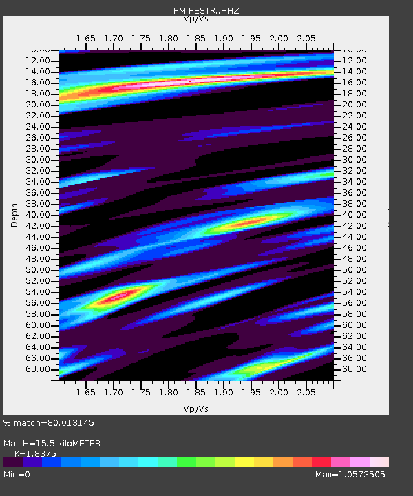
| Estimated Moho Depth: |
15.5 km |
| Estimated Crust Vp/Vs: |
1.84 |
| Assumed Crust Vp: |
6.276 km/s |
| Estimated Crust Vs: |
3.415 km/s |
| Estimated Crust Poisson's Ratio: |
0.29 |
|
| Radial Match: |
80.013145 % |
| Radial Bump: |
400 |
| Transverse Match: |
57.502876 % |
| Transverse Bump: |
275 |
| SOD ConfigId: |
7422571 |
| Insert Time: |
2019-04-20 04:45:56.891 +0000 |
| GWidth: |
2.5 |
| Max Bumps: |
400 |
| Tol: |
0.001 |
|

Signal To Noise
| Channel | StoN | STA | LTA |
| PM:PESTR: :HHZ:20150807T01:33:46.409983Z | 3.5391273 | 5.033184E-7 | 1.422154E-7 |
| PM:PESTR: :HHN:20150807T01:33:46.409983Z | 0.85215026 | 1.3077678E-7 | 1.5346681E-7 |
| PM:PESTR: :HHE:20150807T01:33:46.409983Z | 1.8672041 | 2.2200636E-7 | 1.1889775E-7 |
| Arrivals |
| Ps | 2.2 SECOND |
| PpPs | 6.7 SECOND |
| PsPs/PpSs | 8.8 SECOND |


