You are here: Home > Network List > XL12 - Hangay Dome, Mongolia Stations List
> Station HV18 HV18 > Earthquake Result Viewer
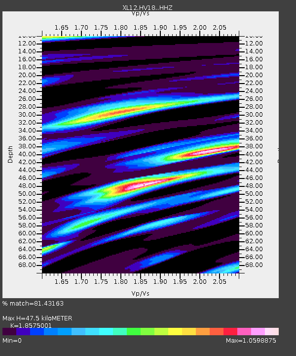
HV18 HV18 - Earthquake Result Viewer
| Earthquake location: |
Lake Tanganyika Region |
| Earthquake latitude/longitude: |
-2.2/28.9 |
| Earthquake time(UTC): |
2015/08/07 (219) 01:25:02 GMT |
| Earthquake Depth: |
10 km |
| Earthquake Magnitude: |
5.6 MB |
| Earthquake Catalog/Contributor: |
NEIC PDE/NEIC COMCAT |
|
| Network: |
XL Hangay Dome, Mongolia |
| Station: |
HV18 HV18 |
| Lat/Lon: |
50.57 N/100.62 E |
| Elevation: |
1696 m |
|
| Distance: |
80.2 deg |
| Az: |
37.92 deg |
| Baz: |
254.388 deg |
| Ray Param: |
0.048465323 |
| Estimated Moho Depth: |
47.5 km |
| Estimated Crust Vp/Vs: |
1.86 |
| Assumed Crust Vp: |
6.419 km/s |
| Estimated Crust Vs: |
3.456 km/s |
| Estimated Crust Poisson's Ratio: |
0.30 |
|
| Radial Match: |
81.43163 % |
| Radial Bump: |
400 |
| Transverse Match: |
67.36604 % |
| Transverse Bump: |
400 |
| SOD ConfigId: |
7422571 |
| Insert Time: |
2019-04-20 04:47:02.628 +0000 |
| GWidth: |
2.5 |
| Max Bumps: |
400 |
| Tol: |
0.001 |
|

Signal To Noise
| Channel | StoN | STA | LTA |
| XL:HV18: :HHZ:20150807T01:36:40.279001Z | 9.332114 | 5.0702494E-7 | 5.4331196E-8 |
| XL:HV18: :HHN:20150807T01:36:40.279001Z | 1.6356934 | 7.84346E-8 | 4.7951897E-8 |
| XL:HV18: :HHE:20150807T01:36:40.279001Z | 5.664175 | 1.7245057E-7 | 3.044584E-8 |
| Arrivals |
| Ps | 6.5 SECOND |
| PpPs | 21 SECOND |
| PsPs/PpSs | 27 SECOND |


