You are here: Home > Network List > IU - Global Seismograph Network (GSN - IRIS/USGS) Stations List
> Station JOHN Johnston Island, USA > Earthquake Result Viewer
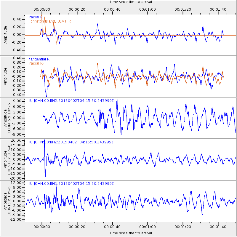
JOHN Johnston Island, USA - Earthquake Result Viewer
*The percent match for this event was below the threshold and hence no stack was calculated.
| Earthquake location: |
Fiji Islands Region |
| Earthquake latitude/longitude: |
-17.8/-178.7 |
| Earthquake time(UTC): |
2015/04/02 (092) 04:10:09 GMT |
| Earthquake Depth: |
536 km |
| Earthquake Magnitude: |
6.0 MWP |
| Earthquake Catalog/Contributor: |
NEIC PDE/NEIC COMCAT |
|
| Network: |
IU Global Seismograph Network (GSN - IRIS/USGS) |
| Station: |
JOHN Johnston Island, USA |
| Lat/Lon: |
16.73 N/169.53 W |
| Elevation: |
2.0 m |
|
| Distance: |
35.5 deg |
| Az: |
15.203 deg |
| Baz: |
195.114 deg |
| Ray Param: |
$rayparam |
*The percent match for this event was below the threshold and hence was not used in the summary stack. |
|
| Radial Match: |
38.688114 % |
| Radial Bump: |
400 |
| Transverse Match: |
64.52793 % |
| Transverse Bump: |
400 |
| SOD ConfigId: |
872571 |
| Insert Time: |
2015-04-16 04:27:44.954 +0000 |
| GWidth: |
2.5 |
| Max Bumps: |
400 |
| Tol: |
0.001 |
|
Signal To Noise
| Channel | StoN | STA | LTA |
| IU:JOHN:00:BHZ:20150402T04:15:50.243999Z | 2.7972543 | 6.7798305E-6 | 2.4237447E-6 |
| IU:JOHN:00:BH1:20150402T04:15:50.243999Z | 0.8401059 | 2.3319822E-6 | 2.7758194E-6 |
| IU:JOHN:00:BH2:20150402T04:15:50.243999Z | 1.3385344 | 2.7192716E-6 | 2.0315292E-6 |
| Arrivals |
| Ps | |
| PpPs | |
| PsPs/PpSs | |


