You are here: Home > Network List > NI - North-East Italy Broadband Network Stations List
> Station CGRP Cima Grappa > Earthquake Result Viewer
CGRP Cima Grappa - Earthquake Result Viewer
| Earthquake location: |
Lake Tanganyika Region |
| Earthquake latitude/longitude: |
-2.1/28.9 |
| Earthquake time(UTC): |
2015/08/07 (219) 01:28:37 GMT |
| Earthquake Depth: |
10 km |
| Earthquake Magnitude: |
5.5 MB |
| Earthquake Catalog/Contributor: |
NEIC PDE/NEIC COMCAT |
|
| Network: |
NI North-East Italy Broadband Network |
| Station: |
CGRP Cima Grappa |
| Lat/Lon: |
45.88 N/11.80 E |
| Elevation: |
1757 m |
|
| Distance: |
50.1 deg |
| Az: |
344.454 deg |
| Baz: |
157.455 deg |
| Ray Param: |
0.06826176 |
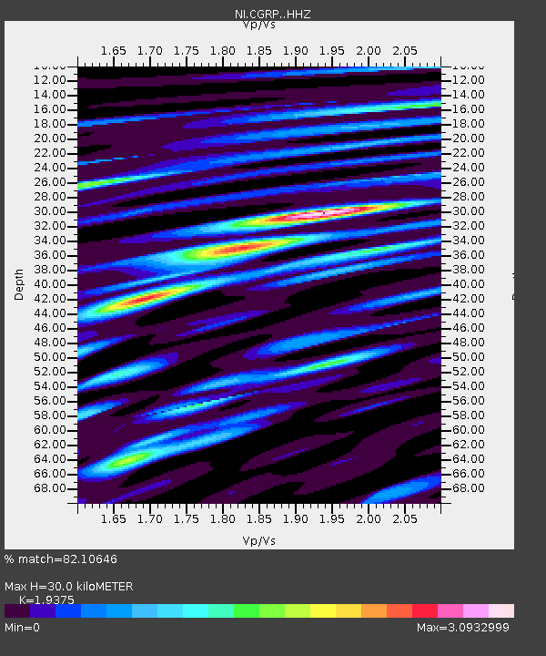
| Estimated Moho Depth: |
30.0 km |
| Estimated Crust Vp/Vs: |
1.94 |
| Assumed Crust Vp: |
6.155 km/s |
| Estimated Crust Vs: |
3.177 km/s |
| Estimated Crust Poisson's Ratio: |
0.32 |
|
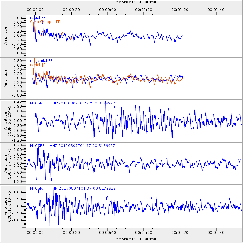
| Radial Match: |
82.10646 % |
| Radial Bump: |
400 |
| Transverse Match: |
60.625507 % |
| Transverse Bump: |
400 |
| SOD ConfigId: |
7422571 |
| Insert Time: |
2019-04-20 04:49:29.470 +0000 |
| GWidth: |
2.5 |
| Max Bumps: |
400 |
| Tol: |
0.001 |
|
Signal To Noise
| Channel | StoN | STA | LTA |
| NI:CGRP: :HHZ:20150807T01:37:00.817992Z | 3.9779317 | 5.6437636E-7 | 1.4187684E-7 |
| NI:CGRP: :HHN:20150807T01:37:00.817992Z | 2.0513701 | 4.4031353E-7 | 2.1464362E-7 |
| NI:CGRP: :HHE:20150807T01:37:00.817992Z | 1.9443122 | 4.6183393E-7 | 2.3753074E-7 |
| Arrivals |
| Ps | 4.8 SECOND |
| PpPs | 14 SECOND |
| PsPs/PpSs | 18 SECOND |


