You are here: Home > Network List > IU - Global Seismograph Network (GSN - IRIS/USGS) Stations List
> Station PMG Port Moresby, New Guinea > Earthquake Result Viewer
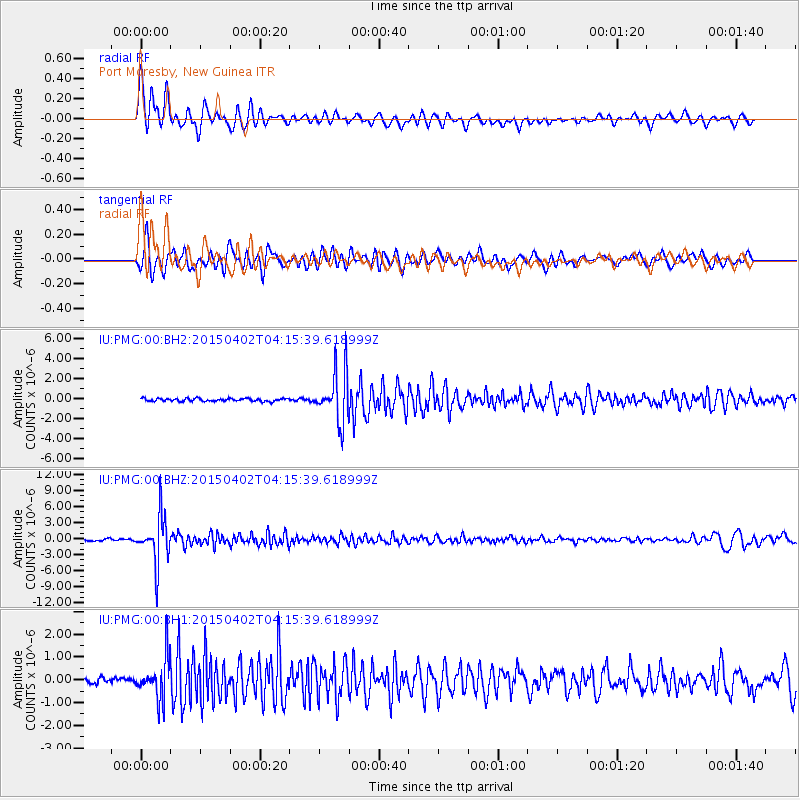
PMG Port Moresby, New Guinea - Earthquake Result Viewer
*The percent match for this event was below the threshold and hence no stack was calculated.
| Earthquake location: |
Fiji Islands Region |
| Earthquake latitude/longitude: |
-17.8/-178.7 |
| Earthquake time(UTC): |
2015/04/02 (092) 04:10:09 GMT |
| Earthquake Depth: |
536 km |
| Earthquake Magnitude: |
6.0 MWP |
| Earthquake Catalog/Contributor: |
NEIC PDE/NEIC COMCAT |
|
| Network: |
IU Global Seismograph Network (GSN - IRIS/USGS) |
| Station: |
PMG Port Moresby, New Guinea |
| Lat/Lon: |
9.40 S/147.16 E |
| Elevation: |
90 m |
|
| Distance: |
34.2 deg |
| Az: |
279.563 deg |
| Baz: |
107.802 deg |
| Ray Param: |
$rayparam |
*The percent match for this event was below the threshold and hence was not used in the summary stack. |
|
| Radial Match: |
84.99805 % |
| Radial Bump: |
400 |
| Transverse Match: |
79.772964 % |
| Transverse Bump: |
400 |
| SOD ConfigId: |
872571 |
| Insert Time: |
2015-04-16 04:28:18.413 +0000 |
| GWidth: |
2.5 |
| Max Bumps: |
400 |
| Tol: |
0.001 |
|
Signal To Noise
| Channel | StoN | STA | LTA |
| IU:PMG:00:BHZ:20150402T04:15:39.618999Z | 26.44351 | 4.2834367E-6 | 1.6198442E-7 |
| IU:PMG:00:BH1:20150402T04:15:39.618999Z | 5.2443423 | 9.0514277E-7 | 1.7259414E-7 |
| IU:PMG:00:BH2:20150402T04:15:39.618999Z | 17.683401 | 2.5638287E-6 | 1.4498504E-7 |
| Arrivals |
| Ps | |
| PpPs | |
| PsPs/PpSs | |


