You are here: Home > Network List > IU - Global Seismograph Network (GSN - IRIS/USGS) Stations List
> Station SBA Scott Base, Antarctica > Earthquake Result Viewer
SBA Scott Base, Antarctica - Earthquake Result Viewer
| Earthquake location: |
Fiji Islands Region |
| Earthquake latitude/longitude: |
-19.8/-178.4 |
| Earthquake time(UTC): |
2002/10/17 (290) 04:23:55 GMT |
| Earthquake Depth: |
628 km |
| Earthquake Magnitude: |
5.5 MB, 6.4 MW, 6.2 MW |
| Earthquake Catalog/Contributor: |
WHDF/NEIC |
|
| Network: |
IU Global Seismograph Network (GSN - IRIS/USGS) |
| Station: |
SBA Scott Base, Antarctica |
| Lat/Lon: |
77.85 S/166.76 E |
| Elevation: |
20 m |
|
| Distance: |
58.5 deg |
| Az: |
183.649 deg |
| Baz: |
16.428 deg |
| Ray Param: |
0.060172528 |
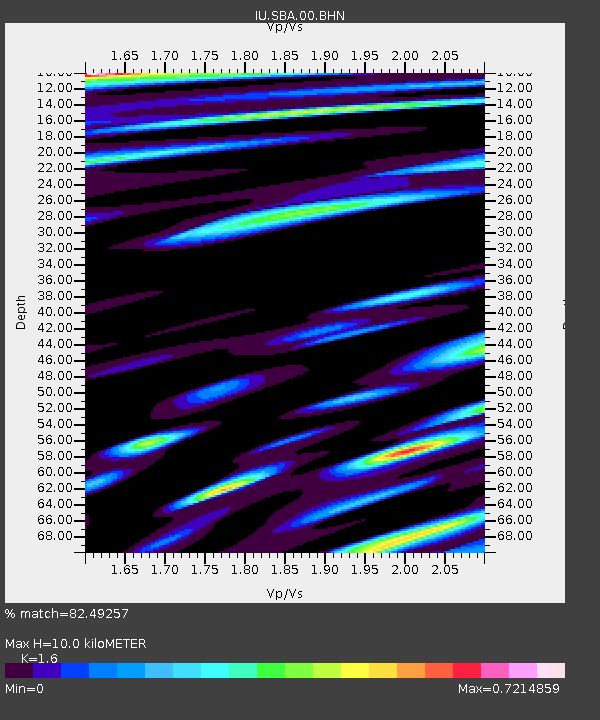
| Estimated Moho Depth: |
10.0 km |
| Estimated Crust Vp/Vs: |
1.60 |
| Assumed Crust Vp: |
6.183 km/s |
| Estimated Crust Vs: |
3.864 km/s |
| Estimated Crust Poisson's Ratio: |
0.18 |
|
| Radial Match: |
82.49257 % |
| Radial Bump: |
400 |
| Transverse Match: |
76.563515 % |
| Transverse Bump: |
400 |
| SOD ConfigId: |
4714 |
| Insert Time: |
2010-03-04 14:48:54.211 +0000 |
| GWidth: |
2.5 |
| Max Bumps: |
400 |
| Tol: |
0.001 |
|
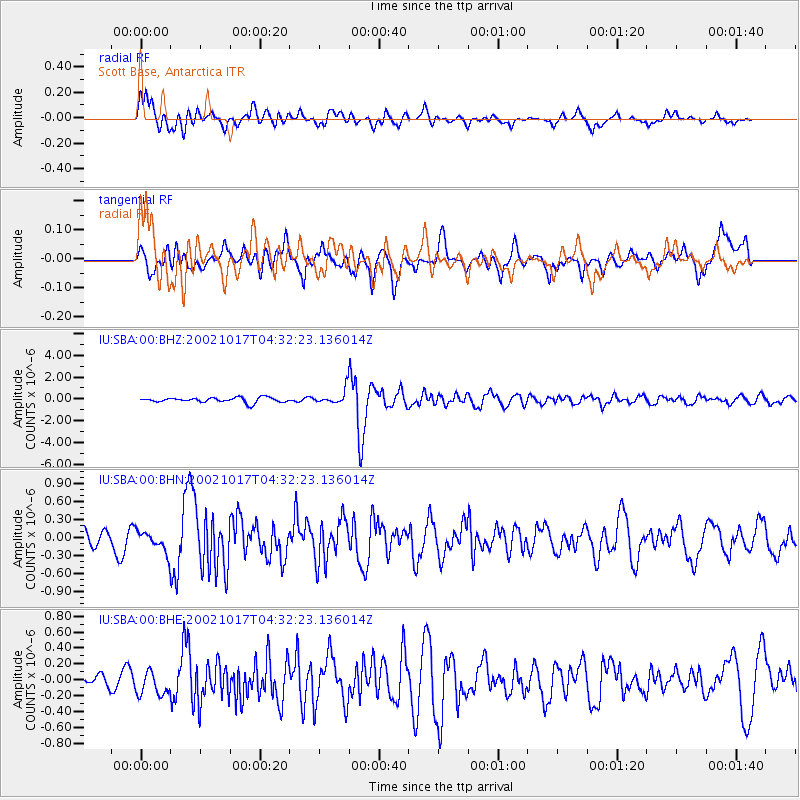
Signal To Noise
| Channel | StoN | STA | LTA |
| IU:SBA:00:BHN:20021017T04:32:23.136014Z | 1.2349603 | 1.7353491E-7 | 1.4051862E-7 |
| IU:SBA:00:BHE:20021017T04:32:23.136014Z | 1.473274 | 1.479718E-7 | 1.004374E-7 |
| IU:SBA:00:BHZ:20021017T04:32:23.136014Z | 2.9522114 | 6.7098125E-7 | 2.272809E-7 |
| Arrivals |
| Ps | 1.0 SECOND |
| PpPs | 4.0 SECOND |
| PsPs/PpSs | 5.0 SECOND |


