You are here: Home > Network List > IU - Global Seismograph Network (GSN - IRIS/USGS) Stations List
> Station SBA Scott Base, Antarctica > Earthquake Result Viewer
SBA Scott Base, Antarctica - Earthquake Result Viewer
| Earthquake location: |
South Sandwich Islands Region |
| Earthquake latitude/longitude: |
-56.5/-27.5 |
| Earthquake time(UTC): |
2002/11/12 (316) 01:46:48 GMT |
| Earthquake Depth: |
120 km |
| Earthquake Magnitude: |
6.0 MB, 6.3 MW, 6.2 MW |
| Earthquake Catalog/Contributor: |
WHDF/NEIC |
|
| Network: |
IU Global Seismograph Network (GSN - IRIS/USGS) |
| Station: |
SBA Scott Base, Antarctica |
| Lat/Lon: |
77.85 S/166.76 E |
| Elevation: |
20 m |
|
| Distance: |
45.6 deg |
| Az: |
184.2 deg |
| Baz: |
168.961 deg |
| Ray Param: |
0.070776805 |
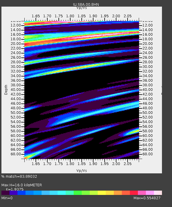
| Estimated Moho Depth: |
16.0 km |
| Estimated Crust Vp/Vs: |
1.94 |
| Assumed Crust Vp: |
6.183 km/s |
| Estimated Crust Vs: |
3.191 km/s |
| Estimated Crust Poisson's Ratio: |
0.32 |
|
| Radial Match: |
83.89032 % |
| Radial Bump: |
352 |
| Transverse Match: |
72.15692 % |
| Transverse Bump: |
387 |
| SOD ConfigId: |
4714 |
| Insert Time: |
2010-03-04 14:49:04.480 +0000 |
| GWidth: |
2.5 |
| Max Bumps: |
400 |
| Tol: |
0.001 |
|
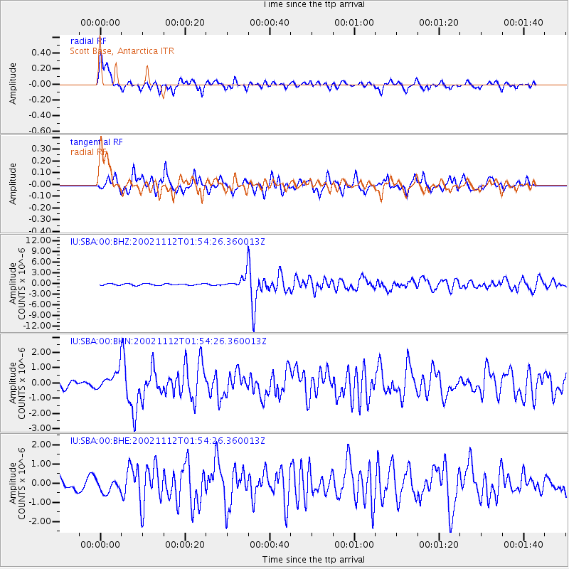
Signal To Noise
| Channel | StoN | STA | LTA |
| IU:SBA:00:BHN:20021112T01:54:26.360013Z | 3.5352433 | 6.398446E-7 | 1.8099026E-7 |
| IU:SBA:00:BHE:20021112T01:54:26.360013Z | 0.7928883 | 3.4720307E-7 | 4.378966E-7 |
| IU:SBA:00:BHZ:20021112T01:54:26.360013Z | 9.368077 | 2.1315732E-6 | 2.275358E-7 |
| Arrivals |
| Ps | 2.6 SECOND |
| PpPs | 7.2 SECOND |
| PsPs/PpSs | 9.8 SECOND |


