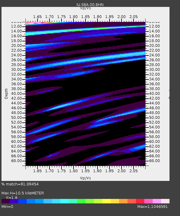
SBA Scott Base, Antarctica - Earthquake Result Viewer
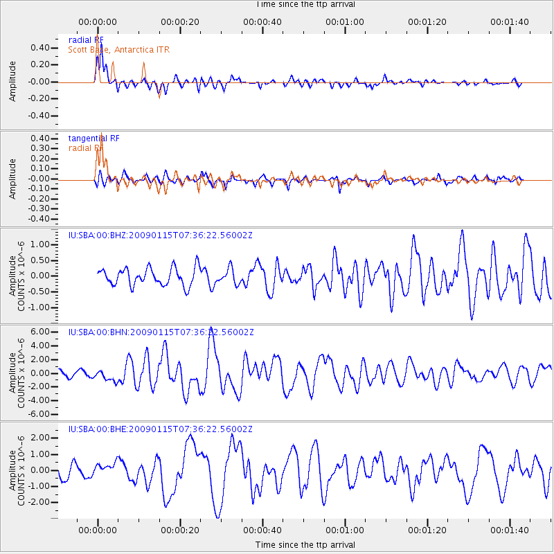
Earthquake location: Southeast Of Loyalty Islands
Earthquake latitude/longitude: -22.4/170.6
Earthquake time(UTC): 2009/01/15 (015) 07:27:20 GMT
Earthquake Depth: 27 km
Earthquake Magnitude: 5.8 MB, 6.5 MS, 6.7 MW, 6.6 MW
Earthquake Catalog/Contributor: WHDF/NEIC
Network: IU Global Seismograph Network (GSN - IRIS/USGS)
Station: SBA Scott Base, Antarctica
Lat/Lon: 77.85 S/166.76 E
Elevation: 20 m
Distance: 55.6 deg
Az: 180.995 deg
Baz: 4.352 deg
Ray Param: 0.06465523
Estimated Moho Depth: 10.5 km
Estimated Crust Vp/Vs: 1.60
Assumed Crust Vp: 6.183 km/s
Estimated Crust Vs: 3.864 km/s
Estimated Crust Poisson's Ratio: 0.18
Radial Match: 91.89454 %
Radial Bump: 357
Transverse Match: 69.90135 %
Transverse Bump: 400
SOD ConfigId: 2834
Insert Time: 2010-03-04 14:50:48.393 +0000
GWidth: 2.5
Max Bumps: 400
Tol: 0.001

Signal To Noise

ChannelStoNSTALTA
IU:SBA:00:BHN:20090115T07:36:22.56002Z2.3072488.00391E-73.4690285E-7
IU:SBA:00:BHE:20090115T07:36:22.56002Z1.08654253.8996038E-73.5890025E-7
IU:SBA:00:BHZ:20090115T07:36:22.56002Z0.87416262.4005445E-72.7461073E-7
Arrivals
Ps1.1 SECOND
PpPs4.2 SECOND
PsPs/PpSs5.3 SECOND