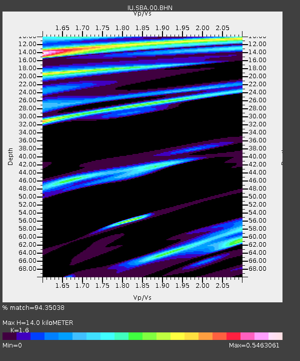
SBA Scott Base, Antarctica - Earthquake Result Viewer
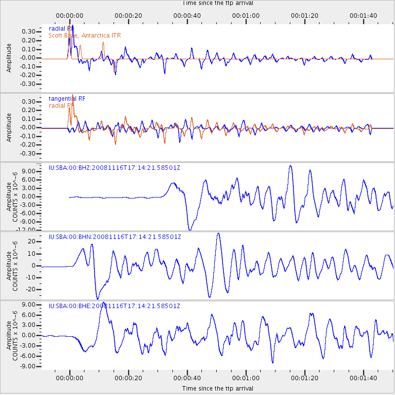
Earthquake location: Minahassa Peninsula, Sulawesi
Earthquake latitude/longitude: 1.3/122.1
Earthquake time(UTC): 2008/11/16 (321) 17:02:32 GMT
Earthquake Depth: 30 km
Earthquake Magnitude: 6.5 MB, 7.0 MS, 7.3 MW, 7.3 MW
Earthquake Catalog/Contributor: WHDF/NEIC
Network: IU Global Seismograph Network (GSN - IRIS/USGS)
Station: SBA Scott Base, Antarctica
Lat/Lon: 77.85 S/166.76 E
Elevation: 20 m
Distance: 82.6 deg
Az: 171.363 deg
Baz: 314.868 deg
Ray Param: 0.046749085
Estimated Moho Depth: 14.0 km
Estimated Crust Vp/Vs: 1.60
Assumed Crust Vp: 6.183 km/s
Estimated Crust Vs: 3.864 km/s
Estimated Crust Poisson's Ratio: 0.18
Radial Match: 94.35038 %
Radial Bump: 313
Transverse Match: 90.37744 %
Transverse Bump: 400
SOD ConfigId: 2658
Insert Time: 2010-03-04 14:51:17.640 +0000
GWidth: 2.5
Max Bumps: 400
Tol: 0.001

Signal To Noise

ChannelStoNSTALTA
IU:SBA:00:BHN:20081116T17:14:21.58501Z56.5003177.825996E-61.3851242E-7
IU:SBA:00:BHE:20081116T17:14:21.58501Z23.0699731.7592017E-67.625504E-8
IU:SBA:00:BHZ:20081116T17:14:21.58501Z17.9139562.1723554E-61.212661E-7
Arrivals
Ps1.4 SECOND
PpPs5.7 SECOND
PsPs/PpSs7.1 SECOND