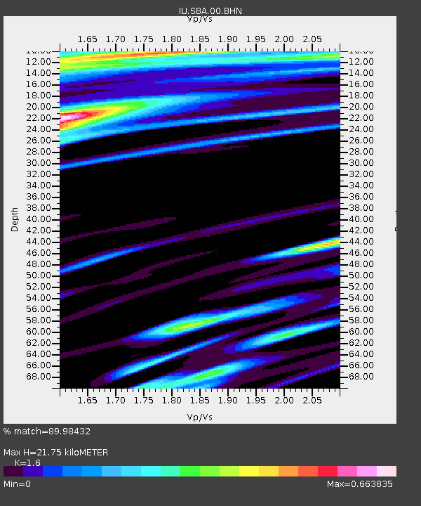
SBA Scott Base, Antarctica - Earthquake Result Viewer
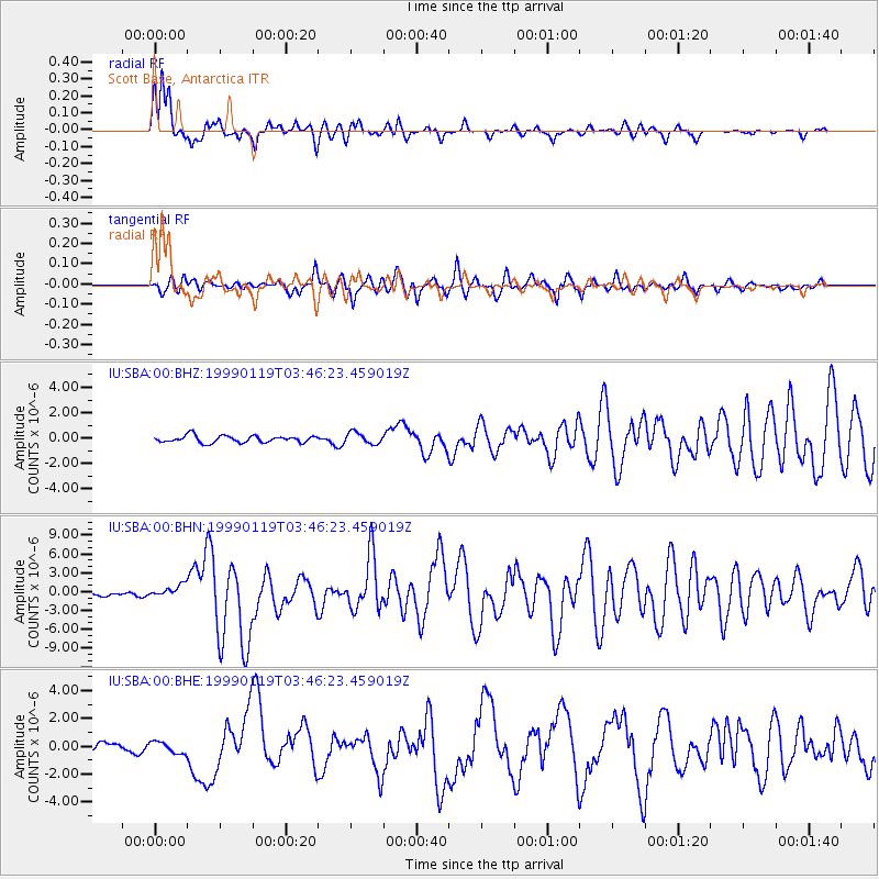
Earthquake location: New Ireland Region, P.N.G.
Earthquake latitude/longitude: -4.6/153.2
Earthquake time(UTC): 1999/01/19 (019) 03:35:33 GMT
Earthquake Depth: 114 km
Earthquake Magnitude: 5.8 MB, 6.4 MS, 7.0 MW, 6.5 ME
Earthquake Catalog/Contributor: WHDF/NEIC
Network: IU Global Seismograph Network (GSN - IRIS/USGS)
Station: SBA Scott Base, Antarctica
Lat/Lon: 77.85 S/166.76 E
Elevation: 20 m
Distance: 73.6 deg
Az: 177.04 deg
Baz: 345.935 deg
Ray Param: 0.05264524
Estimated Moho Depth: 21.75 km
Estimated Crust Vp/Vs: 1.60
Assumed Crust Vp: 6.183 km/s
Estimated Crust Vs: 3.864 km/s
Estimated Crust Poisson's Ratio: 0.18
Radial Match: 89.98432 %
Radial Bump: 384
Transverse Match: 62.225243 %
Transverse Bump: 400
SOD ConfigId: 4480
Insert Time: 2010-03-04 14:51:45.446 +0000
GWidth: 2.5
Max Bumps: 400
Tol: 0.001

Signal To Noise

ChannelStoNSTALTA
IU:SBA:00:BHN:19990119T03:46:23.459019Z2.4519369.695904E-73.9543866E-7
IU:SBA:00:BHE:19990119T03:46:23.459019Z1.16235664.216093E-73.627194E-7
IU:SBA:00:BHZ:19990119T03:46:23.459019Z1.65781494.4943292E-72.710996E-7
Arrivals
Ps2.2 SECOND
PpPs8.8 SECOND
PsPs/PpSs11 SECOND