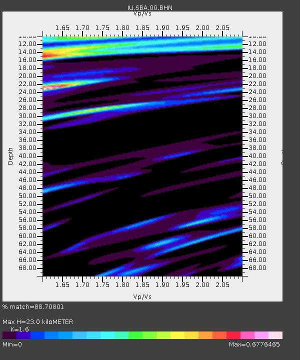
SBA Scott Base, Antarctica - Earthquake Result Viewer
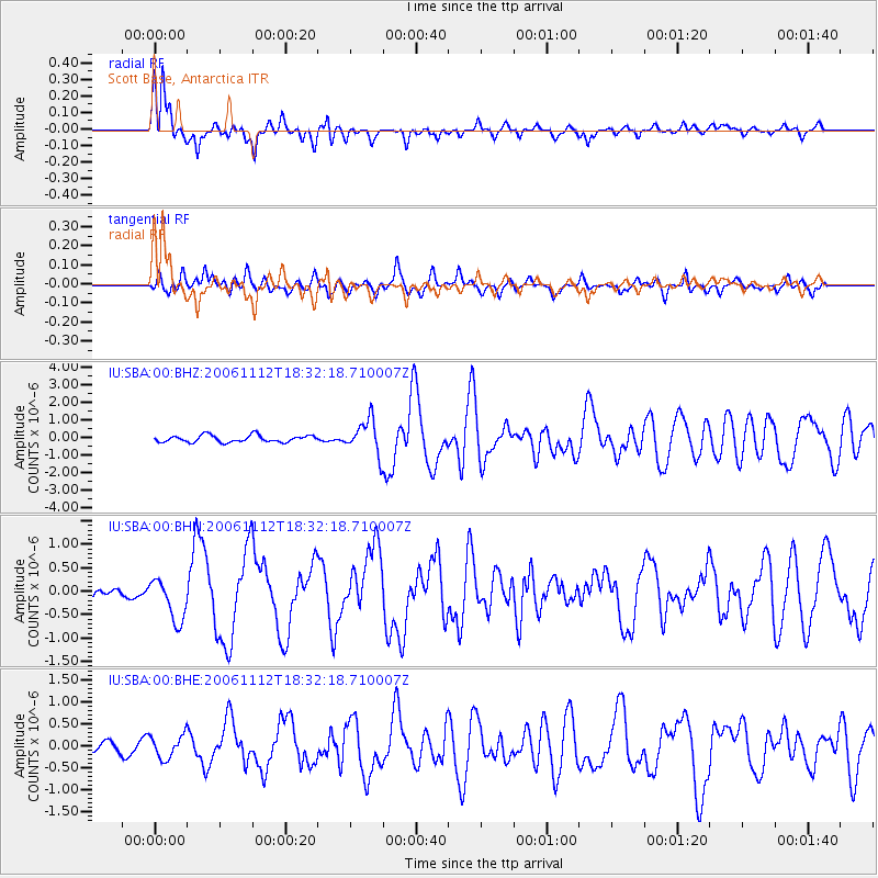
Earthquake location: New Britain Region, P.N.G.
Earthquake latitude/longitude: -6.2/151.1
Earthquake time(UTC): 2006/11/12 (316) 18:21:26 GMT
Earthquake Depth: 12 km
Earthquake Magnitude: 6.0 MB, 6.0 MS, 6.2 MW, 6.1 MW
Earthquake Catalog/Contributor: WHDF/NEIC
Network: IU Global Seismograph Network (GSN - IRIS/USGS)
Station: SBA Scott Base, Antarctica
Lat/Lon: 77.85 S/166.76 E
Elevation: 20 m
Distance: 72.1 deg
Az: 176.544 deg
Baz: 343.567 deg
Ray Param: 0.053908348
Estimated Moho Depth: 23.0 km
Estimated Crust Vp/Vs: 1.60
Assumed Crust Vp: 6.183 km/s
Estimated Crust Vs: 3.864 km/s
Estimated Crust Poisson's Ratio: 0.18
Radial Match: 88.70801 %
Radial Bump: 335
Transverse Match: 61.44548 %
Transverse Bump: 400
SOD ConfigId: 2564
Insert Time: 2010-03-04 14:51:58.272 +0000
GWidth: 2.5
Max Bumps: 400
Tol: 0.001

Signal To Noise

ChannelStoNSTALTA
IU:SBA:00:BHN:20061112T18:32:18.710007Z2.400094.5651583E-71.902078E-7
IU:SBA:00:BHE:20061112T18:32:18.710007Z1.4447912.623071E-71.8155369E-7
IU:SBA:00:BHZ:20061112T18:32:18.710007Z4.9989919.777773E-71.9559494E-7
Arrivals
Ps2.3 SECOND
PpPs9.3 SECOND
PsPs/PpSs12 SECOND