You are here: Home > Network List > IU - Global Seismograph Network (GSN - IRIS/USGS) Stations List
> Station SBA Scott Base, Antarctica > Earthquake Result Viewer
SBA Scott Base, Antarctica - Earthquake Result Viewer
| Earthquake location: |
Flores Sea |
| Earthquake latitude/longitude: |
-7.2/120.1 |
| Earthquake time(UTC): |
2006/09/09 (252) 04:13:12 GMT |
| Earthquake Depth: |
572 km |
| Earthquake Magnitude: |
6.0 MB, 6.3 MW, 6.3 MW |
| Earthquake Catalog/Contributor: |
WHDF/NEIC |
|
| Network: |
IU Global Seismograph Network (GSN - IRIS/USGS) |
| Station: |
SBA Scott Base, Antarctica |
| Lat/Lon: |
77.85 S/166.76 E |
| Elevation: |
20 m |
|
| Distance: |
74.6 deg |
| Az: |
170.804 deg |
| Baz: |
311.538 deg |
| Ray Param: |
0.050396845 |
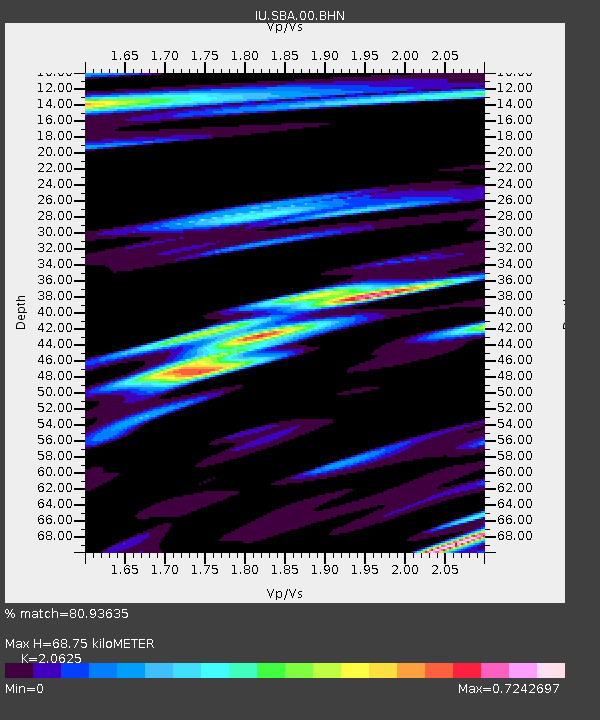
| Estimated Moho Depth: |
68.75 km |
| Estimated Crust Vp/Vs: |
2.06 |
| Assumed Crust Vp: |
6.183 km/s |
| Estimated Crust Vs: |
2.998 km/s |
| Estimated Crust Poisson's Ratio: |
0.35 |
|
| Radial Match: |
80.93635 % |
| Radial Bump: |
400 |
| Transverse Match: |
67.12077 % |
| Transverse Bump: |
351 |
| SOD ConfigId: |
2665 |
| Insert Time: |
2010-03-04 14:52:03.861 +0000 |
| GWidth: |
2.5 |
| Max Bumps: |
400 |
| Tol: |
0.001 |
|
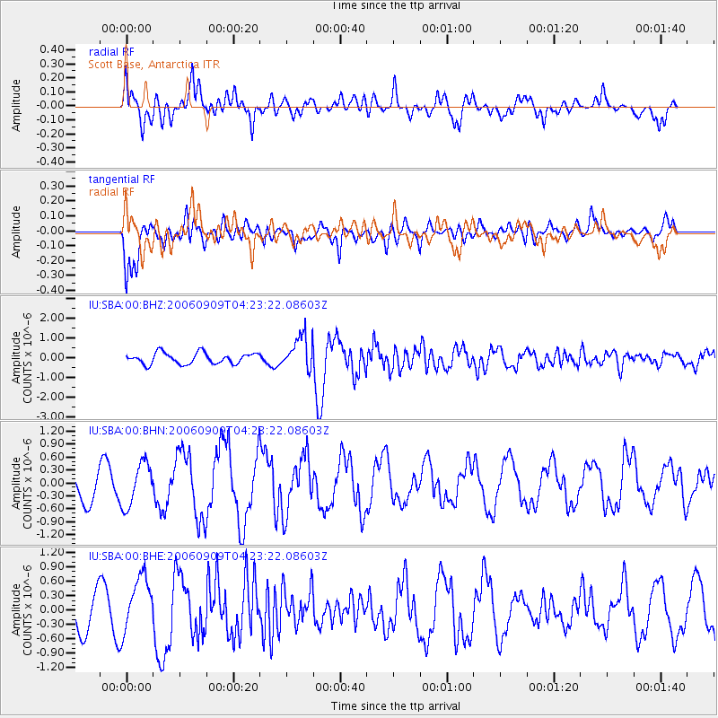
Signal To Noise
| Channel | StoN | STA | LTA |
| IU:SBA:00:BHN:20060909T04:23:22.08603Z | 1.1775993 | 5.0314054E-7 | 4.2725955E-7 |
| IU:SBA:00:BHE:20060909T04:23:22.08603Z | 1.6883565 | 5.7884546E-7 | 3.428455E-7 |
| IU:SBA:00:BHZ:20060909T04:23:22.08603Z | 3.0530348 | 8.5537624E-7 | 2.8017246E-7 |
| Arrivals |
| Ps | 12 SECOND |
| PpPs | 33 SECOND |
| PsPs/PpSs | 45 SECOND |


