You are here: Home > Network List > IU - Global Seismograph Network (GSN - IRIS/USGS) Stations List
> Station SBA Scott Base, Antarctica > Earthquake Result Viewer
SBA Scott Base, Antarctica - Earthquake Result Viewer
| Earthquake location: |
New Ireland Region, P.N.G. |
| Earthquake latitude/longitude: |
-5.1/153.2 |
| Earthquake time(UTC): |
2000/11/16 (321) 05:21:22 GMT |
| Earthquake Depth: |
33 km |
| Earthquake Magnitude: |
6.0 MB |
| Earthquake Catalog/Contributor: |
WHDF/NEIC |
|
| Network: |
IU Global Seismograph Network (GSN - IRIS/USGS) |
| Station: |
SBA Scott Base, Antarctica |
| Lat/Lon: |
77.85 S/166.76 E |
| Elevation: |
20 m |
|
| Distance: |
73.1 deg |
| Az: |
177.033 deg |
| Baz: |
345.913 deg |
| Ray Param: |
0.05318837 |
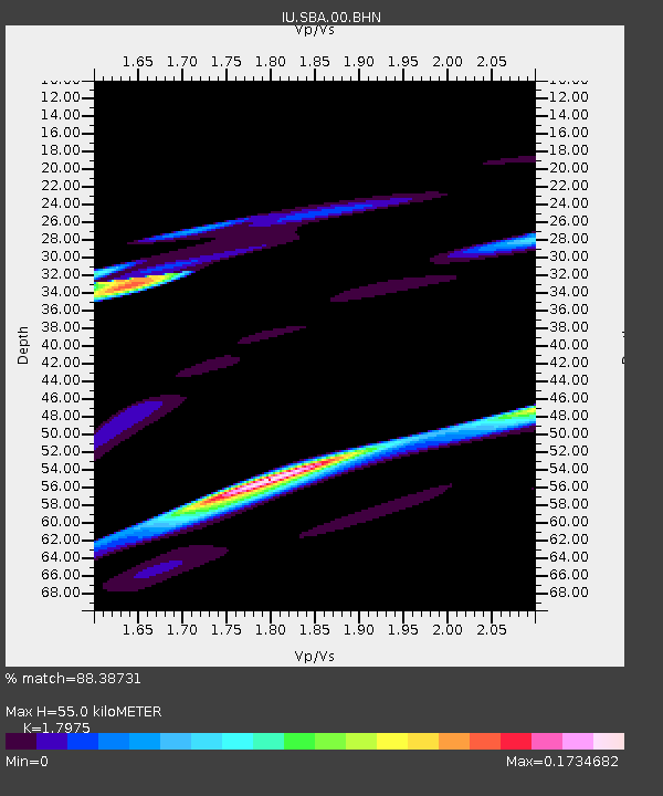
| Estimated Moho Depth: |
55.0 km |
| Estimated Crust Vp/Vs: |
1.80 |
| Assumed Crust Vp: |
6.183 km/s |
| Estimated Crust Vs: |
3.44 km/s |
| Estimated Crust Poisson's Ratio: |
0.28 |
|
| Radial Match: |
88.38731 % |
| Radial Bump: |
400 |
| Transverse Match: |
48.23245 % |
| Transverse Bump: |
313 |
| SOD ConfigId: |
3744 |
| Insert Time: |
2010-03-04 14:52:11.603 +0000 |
| GWidth: |
2.5 |
| Max Bumps: |
400 |
| Tol: |
0.001 |
|
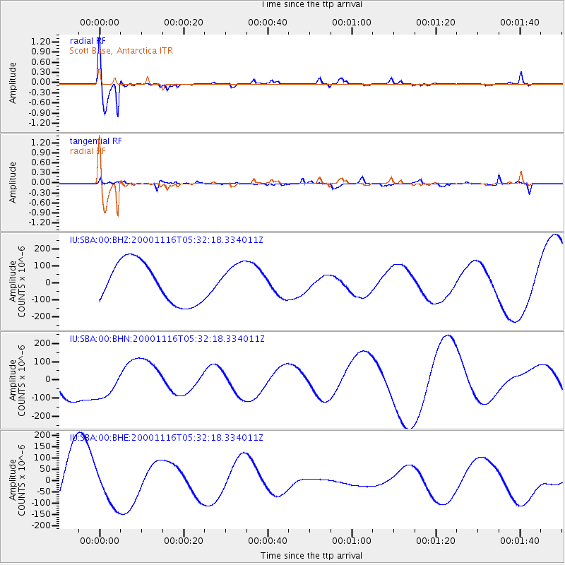
Signal To Noise
| Channel | StoN | STA | LTA |
| IU:SBA:00:BHN:20001116T05:32:18.334011Z | 0.43219087 | 7.02856E-5 | 1.626263E-4 |
| IU:SBA:00:BHE:20001116T05:32:18.334011Z | 0.76372063 | 8.359712E-5 | 1.0946034E-4 |
| IU:SBA:00:BHZ:20001116T05:32:18.334011Z | 0.8517137 | 1.0251603E-4 | 1.2036442E-4 |
| Arrivals |
| Ps | 7.3 SECOND |
| PpPs | 24 SECOND |
| PsPs/PpSs | 31 SECOND |


