You are here: Home > Network List > TA - USArray Transportable Network (new EarthScope stations) Stations List
> Station I23K Minto, Yukon-Koyukuk, AK, USA > Earthquake Result Viewer
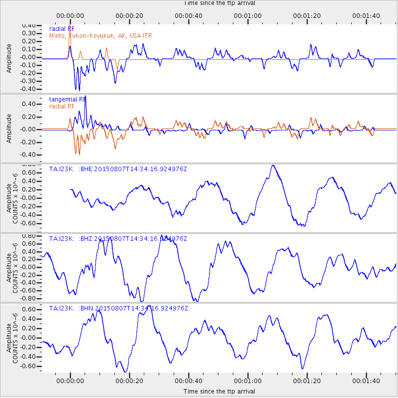
I23K Minto, Yukon-Koyukuk, AK, USA - Earthquake Result Viewer
*The percent match for this event was below the threshold and hence no stack was calculated.
| Earthquake location: |
Tonga Islands |
| Earthquake latitude/longitude: |
-18.1/-174.2 |
| Earthquake time(UTC): |
2015/08/07 (219) 14:22:13 GMT |
| Earthquake Depth: |
20 km |
| Earthquake Magnitude: |
5.7 MW |
| Earthquake Catalog/Contributor: |
ISC/ISC |
|
| Network: |
TA USArray Transportable Network (new EarthScope stations) |
| Station: |
I23K Minto, Yukon-Koyukuk, AK, USA |
| Lat/Lon: |
65.15 N/149.36 W |
| Elevation: |
149 m |
|
| Distance: |
85.1 deg |
| Az: |
10.245 deg |
| Baz: |
203.601 deg |
| Ray Param: |
$rayparam |
*The percent match for this event was below the threshold and hence was not used in the summary stack. |
|
| Radial Match: |
71.20233 % |
| Radial Bump: |
400 |
| Transverse Match: |
95.09086 % |
| Transverse Bump: |
343 |
| SOD ConfigId: |
7422571 |
| Insert Time: |
2019-04-20 05:20:04.825 +0000 |
| GWidth: |
2.5 |
| Max Bumps: |
400 |
| Tol: |
0.001 |
|
Signal To Noise
| Channel | StoN | STA | LTA |
| TA:I23K: :BHZ:20150807T14:34:16.924976Z | 2.1560445 | 5.237725E-7 | 2.4293215E-7 |
| TA:I23K: :BHN:20150807T14:34:16.924976Z | 0.86182266 | 2.3223055E-7 | 2.6946444E-7 |
| TA:I23K: :BHE:20150807T14:34:16.924976Z | 1.0955586 | 1.7976427E-7 | 1.6408457E-7 |
| Arrivals |
| Ps | |
| PpPs | |
| PsPs/PpSs | |


