You are here: Home > Network List > TA - USArray Transportable Network (new EarthScope stations) Stations List
> Station J20K Nowitna River, AK, USA > Earthquake Result Viewer
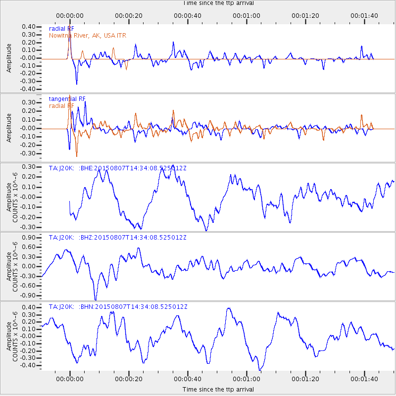
J20K Nowitna River, AK, USA - Earthquake Result Viewer
*The percent match for this event was below the threshold and hence no stack was calculated.
| Earthquake location: |
Tonga Islands |
| Earthquake latitude/longitude: |
-18.1/-174.2 |
| Earthquake time(UTC): |
2015/08/07 (219) 14:22:13 GMT |
| Earthquake Depth: |
20 km |
| Earthquake Magnitude: |
5.7 MW |
| Earthquake Catalog/Contributor: |
ISC/ISC |
|
| Network: |
TA USArray Transportable Network (new EarthScope stations) |
| Station: |
J20K Nowitna River, AK, USA |
| Lat/Lon: |
64.18 N/154.15 W |
| Elevation: |
314 m |
|
| Distance: |
83.4 deg |
| Az: |
8.675 deg |
| Baz: |
199.123 deg |
| Ray Param: |
$rayparam |
*The percent match for this event was below the threshold and hence was not used in the summary stack. |
|
| Radial Match: |
76.721535 % |
| Radial Bump: |
400 |
| Transverse Match: |
87.22812 % |
| Transverse Bump: |
400 |
| SOD ConfigId: |
7422571 |
| Insert Time: |
2019-04-20 05:20:06.955 +0000 |
| GWidth: |
2.5 |
| Max Bumps: |
400 |
| Tol: |
0.001 |
|
Signal To Noise
| Channel | StoN | STA | LTA |
| TA:J20K: :BHZ:20150807T14:34:08.525012Z | 1.134275 | 3.121686E-7 | 2.752142E-7 |
| TA:J20K: :BHN:20150807T14:34:08.525012Z | 1.9696707 | 2.6085016E-7 | 1.3243339E-7 |
| TA:J20K: :BHE:20150807T14:34:08.525012Z | 1.4103341 | 2.5800776E-7 | 1.8294087E-7 |
| Arrivals |
| Ps | |
| PpPs | |
| PsPs/PpSs | |


