SBA Scott Base, Antarctica - Earthquake Result Viewer
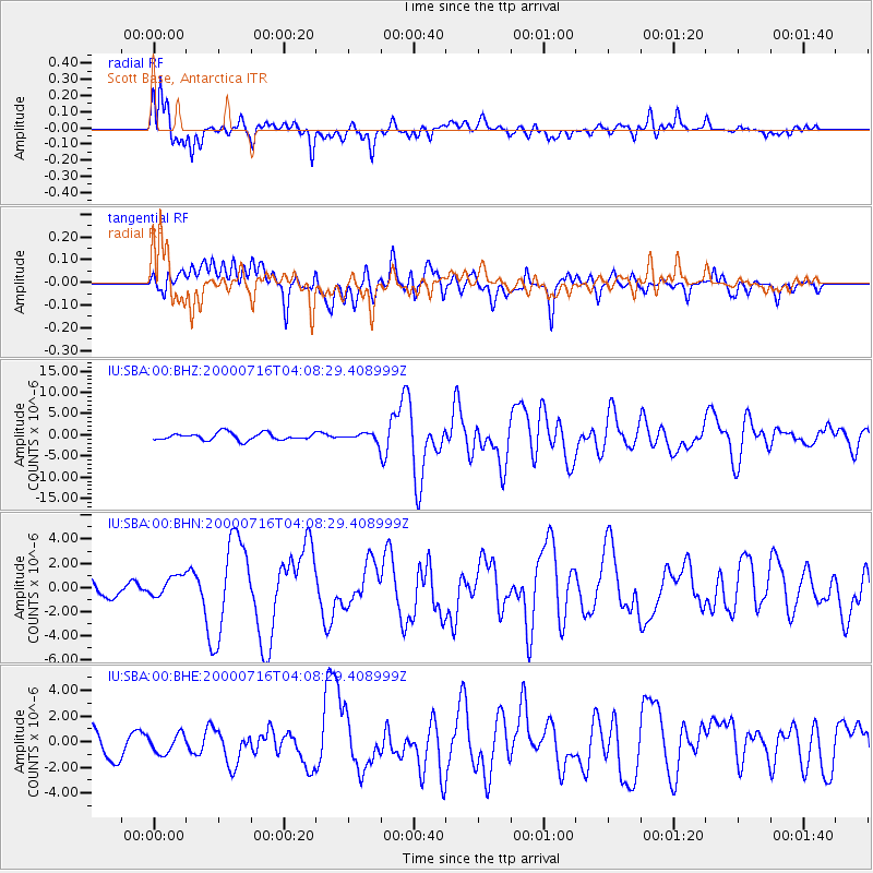
Earthquake location: New Britain Region, P.N.G.
Earthquake latitude/longitude: -7.7/150.9
Earthquake time(UTC): 2000/07/16 (198) 03:57:45 GMT
Earthquake Depth: 10 km
Earthquake Magnitude: 6.3 MB, 6.4 MS, 6.6 MW, 6.6 MW
Earthquake Catalog/Contributor: WHDF/NEIC
Network: IU Global Seismograph Network (GSN - IRIS/USGS)
Station: SBA Scott Base, Antarctica
Lat/Lon: 77.85 S/166.76 E
Elevation: 20 m
Distance: 70.6 deg
Az: 176.484 deg
Baz: 343.33 deg
Ray Param: 0.054902744
Estimated Moho Depth: 11.0 km
Estimated Crust Vp/Vs: 2.10
Assumed Crust Vp: 6.183 km/s
Estimated Crust Vs: 2.948 km/s
Estimated Crust Poisson's Ratio: 0.35
Radial Match: 88.15545 %
Radial Bump: 400
Transverse Match: 71.734825 %
Transverse Bump: 400
SOD ConfigId: 3744
Insert Time: 2010-03-04 14:52:21.544 +0000
GWidth: 2.5
Max Bumps: 400
Tol: 0.001

Signal To Noise

ChannelStoNSTALTA
IU:SBA:00:BHN:20000716T04:08:29.408999Z1.13897178.9211534E-77.832639E-7
IU:SBA:00:BHE:20000716T04:08:29.408999Z0.63865787.3599097E-71.1524027E-6
IU:SBA:00:BHZ:20000716T04:08:29.408999Z1.11999699.546984E-78.5241163E-7
Arrivals
Ps2.0 SECOND
PpPs5.4 SECOND
PsPs/PpSs7.4 SECOND