You are here: Home > Network List > IU - Global Seismograph Network (GSN - IRIS/USGS) Stations List
> Station SBA Scott Base, Antarctica > Earthquake Result Viewer
SBA Scott Base, Antarctica - Earthquake Result Viewer
| Earthquake location: |
Fiji Islands Region |
| Earthquake latitude/longitude: |
-21.2/-179.1 |
| Earthquake time(UTC): |
2000/12/18 (353) 01:19:21 GMT |
| Earthquake Depth: |
628 km |
| Earthquake Magnitude: |
6.4 MB, 6.6 MW, 6.5 MW |
| Earthquake Catalog/Contributor: |
WHDF/NEIC |
|
| Network: |
IU Global Seismograph Network (GSN - IRIS/USGS) |
| Station: |
SBA Scott Base, Antarctica |
| Lat/Lon: |
77.85 S/166.76 E |
| Elevation: |
20 m |
|
| Distance: |
57.1 deg |
| Az: |
183.527 deg |
| Baz: |
15.727 deg |
| Ray Param: |
0.06100169 |
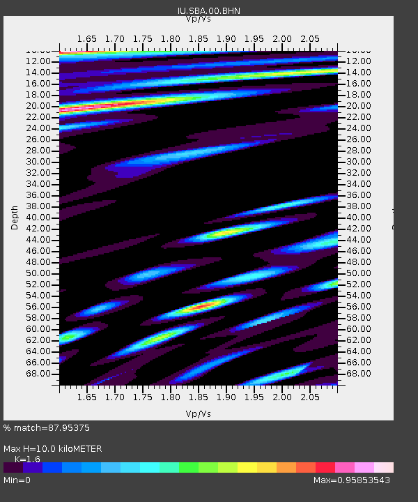
| Estimated Moho Depth: |
10.0 km |
| Estimated Crust Vp/Vs: |
1.60 |
| Assumed Crust Vp: |
6.183 km/s |
| Estimated Crust Vs: |
3.864 km/s |
| Estimated Crust Poisson's Ratio: |
0.18 |
|
| Radial Match: |
87.95375 % |
| Radial Bump: |
400 |
| Transverse Match: |
77.47712 % |
| Transverse Bump: |
400 |
| SOD ConfigId: |
3744 |
| Insert Time: |
2010-03-04 14:52:25.163 +0000 |
| GWidth: |
2.5 |
| Max Bumps: |
400 |
| Tol: |
0.001 |
|
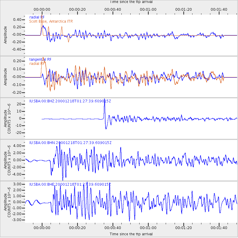
Signal To Noise
| Channel | StoN | STA | LTA |
| IU:SBA:00:BHN:20001218T01:27:39.609015Z | 0.67286277 | 1.5449638E-7 | 2.2961052E-7 |
| IU:SBA:00:BHE:20001218T01:27:39.609015Z | 0.27463487 | 7.738364E-8 | 2.8176916E-7 |
| IU:SBA:00:BHZ:20001218T01:27:39.609015Z | 2.6143556 | 5.371964E-7 | 2.0547947E-7 |
| Arrivals |
| Ps | 1.0 SECOND |
| PpPs | 4.0 SECOND |
| PsPs/PpSs | 5.0 SECOND |


