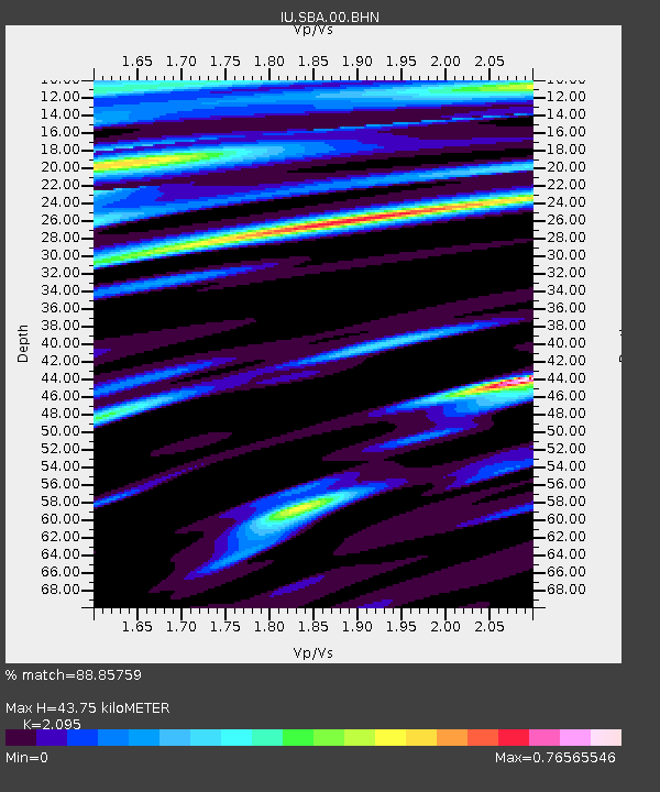
SBA Scott Base, Antarctica - Earthquake Result Viewer
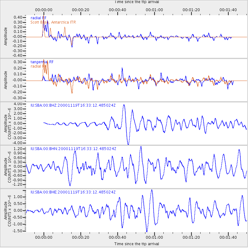
Earthquake location: New Ireland Region, P.N.G.
Earthquake latitude/longitude: -4.8/153.1
Earthquake time(UTC): 2000/11/19 (324) 16:22:14 GMT
Earthquake Depth: 33 km
Earthquake Magnitude: 5.4 MB, 5.8 MS, 6.0 MW, 5.8 MW
Earthquake Catalog/Contributor: WHDF/NEIC
Network: IU Global Seismograph Network (GSN - IRIS/USGS)
Station: SBA Scott Base, Antarctica
Lat/Lon: 77.85 S/166.76 E
Elevation: 20 m
Distance: 73.4 deg
Az: 177.01 deg
Baz: 345.796 deg
Ray Param: 0.05300942
Estimated Moho Depth: 43.75 km
Estimated Crust Vp/Vs: 2.10
Assumed Crust Vp: 6.183 km/s
Estimated Crust Vs: 2.951 km/s
Estimated Crust Poisson's Ratio: 0.35
Radial Match: 88.85759 %
Radial Bump: 359
Transverse Match: 80.56259 %
Transverse Bump: 400
SOD ConfigId: 3744
Insert Time: 2010-03-04 14:52:28.572 +0000
GWidth: 2.5
Max Bumps: 400
Tol: 0.001

Signal To Noise

ChannelStoNSTALTA
IU:SBA:00:BHN:20001119T16:33:12.485024Z0.912071171.4445415E-71.5838035E-7
IU:SBA:00:BHE:20001119T16:33:12.485024Z1.20013051.4995516E-71.2494904E-7
IU:SBA:00:BHZ:20001119T16:33:12.485024Z1.78514243.881494E-72.174333E-7
Arrivals
Ps8.0 SECOND
PpPs21 SECOND
PsPs/PpSs29 SECOND