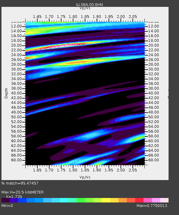
SBA Scott Base, Antarctica - Earthquake Result Viewer
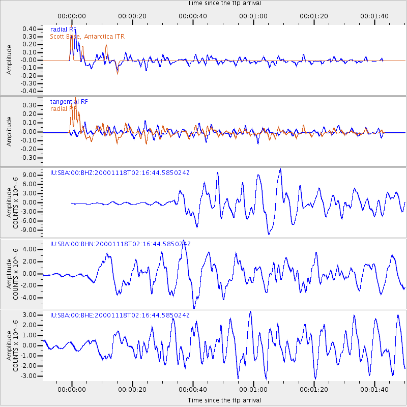
Earthquake location: New Ireland Region, P.N.G.
Earthquake latitude/longitude: -5.1/153.2
Earthquake time(UTC): 2000/11/18 (323) 02:05:48 GMT
Earthquake Depth: 33 km
Earthquake Magnitude: 5.9 MB, 6.6 MS, 6.9 MW, 6.4 ME
Earthquake Catalog/Contributor: WHDF/NEIC
Network: IU Global Seismograph Network (GSN - IRIS/USGS)
Station: SBA Scott Base, Antarctica
Lat/Lon: 77.85 S/166.76 E
Elevation: 20 m
Distance: 73.1 deg
Az: 177.02 deg
Baz: 345.852 deg
Ray Param: 0.053204626
Estimated Moho Depth: 20.5 km
Estimated Crust Vp/Vs: 1.74
Assumed Crust Vp: 6.183 km/s
Estimated Crust Vs: 3.563 km/s
Estimated Crust Poisson's Ratio: 0.25
Radial Match: 95.47457 %
Radial Bump: 400
Transverse Match: 72.97054 %
Transverse Bump: 400
SOD ConfigId: 3744
Insert Time: 2010-03-04 14:52:31.368 +0000
GWidth: 2.5
Max Bumps: 400
Tol: 0.001

Signal To Noise

ChannelStoNSTALTA
IU:SBA:00:BHN:20001118T02:16:44.585024Z1.6515362.2082908E-71.3371134E-7
IU:SBA:00:BHE:20001118T02:16:44.585024Z1.18138413.055685E-72.58653E-7
IU:SBA:00:BHZ:20001118T02:16:44.585024Z2.06744384.987911E-72.412598E-7
Arrivals
Ps2.5 SECOND
PpPs8.8 SECOND
PsPs/PpSs11 SECOND