You are here: Home > Network List > IU - Global Seismograph Network (GSN - IRIS/USGS) Stations List
> Station SBA Scott Base, Antarctica > Earthquake Result Viewer
SBA Scott Base, Antarctica - Earthquake Result Viewer
| Earthquake location: |
Tonga Islands |
| Earthquake latitude/longitude: |
-17.3/-174.0 |
| Earthquake time(UTC): |
2000/01/26 (026) 13:26:50 GMT |
| Earthquake Depth: |
33 km |
| Earthquake Magnitude: |
5.9 MB, 6.0 MS, 6.4 MW, 6.3 MW |
| Earthquake Catalog/Contributor: |
WHDF/NEIC |
|
| Network: |
IU Global Seismograph Network (GSN - IRIS/USGS) |
| Station: |
SBA Scott Base, Antarctica |
| Lat/Lon: |
77.85 S/166.76 E |
| Elevation: |
20 m |
|
| Distance: |
61.3 deg |
| Az: |
184.563 deg |
| Baz: |
21.027 deg |
| Ray Param: |
0.060876727 |
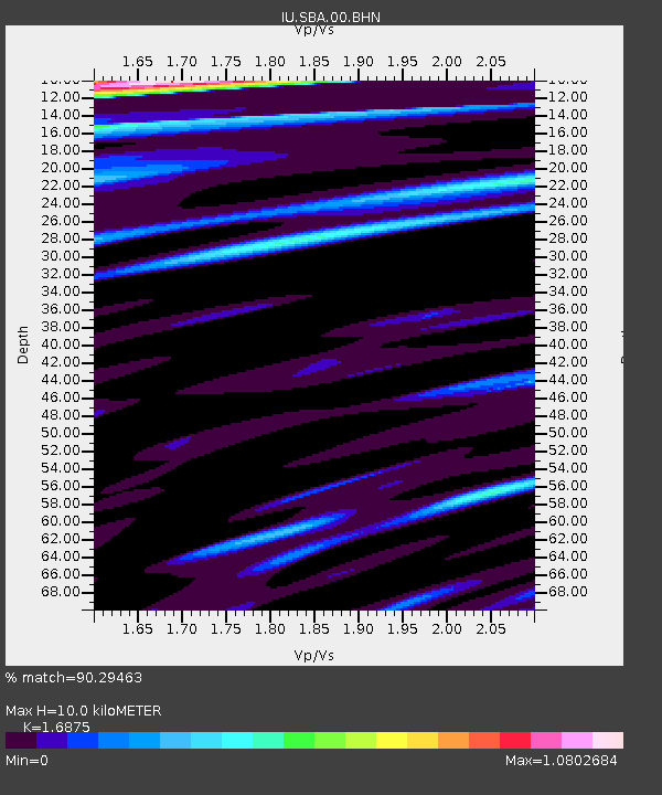
| Estimated Moho Depth: |
10.0 km |
| Estimated Crust Vp/Vs: |
1.69 |
| Assumed Crust Vp: |
6.183 km/s |
| Estimated Crust Vs: |
3.664 km/s |
| Estimated Crust Poisson's Ratio: |
0.23 |
|
| Radial Match: |
90.29463 % |
| Radial Bump: |
400 |
| Transverse Match: |
86.57306 % |
| Transverse Bump: |
400 |
| SOD ConfigId: |
3744 |
| Insert Time: |
2010-03-04 14:52:35.070 +0000 |
| GWidth: |
2.5 |
| Max Bumps: |
400 |
| Tol: |
0.001 |
|
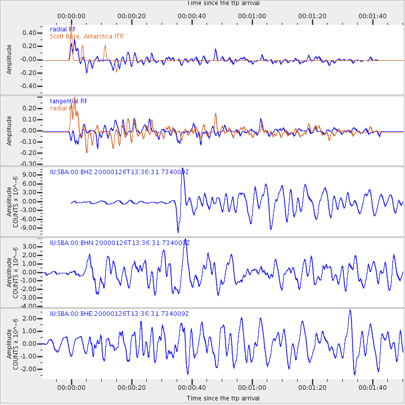
Signal To Noise
| Channel | StoN | STA | LTA |
| IU:SBA:00:BHN:20000126T13:36:31.734009Z | 0.8065763 | 2.2067857E-7 | 2.735991E-7 |
| IU:SBA:00:BHE:20000126T13:36:31.734009Z | 2.0382166 | 5.428946E-7 | 2.663577E-7 |
| IU:SBA:00:BHZ:20000126T13:36:31.734009Z | 1.5107502 | 5.13658E-7 | 3.4000195E-7 |
| Arrivals |
| Ps | 1.2 SECOND |
| PpPs | 4.2 SECOND |
| PsPs/PpSs | 5.3 SECOND |


