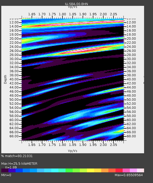
SBA Scott Base, Antarctica - Earthquake Result Viewer
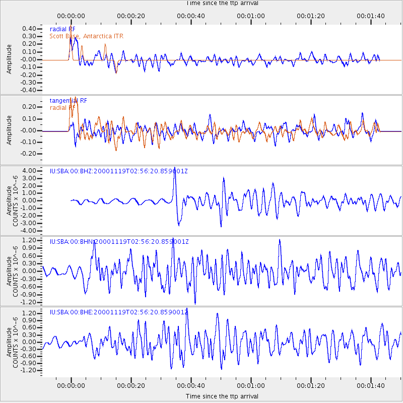
Earthquake location: New Britain Region, P.N.G.
Earthquake latitude/longitude: -5.1/151.7
Earthquake time(UTC): 2000/11/19 (324) 02:45:27 GMT
Earthquake Depth: 58 km
Earthquake Magnitude: 5.8 MB, 5.6 MS, 6.0 MW, 6.0 MW
Earthquake Catalog/Contributor: WHDF/NEIC
Network: IU Global Seismograph Network (GSN - IRIS/USGS)
Station: SBA Scott Base, Antarctica
Lat/Lon: 77.85 S/166.76 E
Elevation: 20 m
Distance: 73.1 deg
Az: 176.693 deg
Baz: 344.263 deg
Ray Param: 0.053104628
Estimated Moho Depth: 25.5 km
Estimated Crust Vp/Vs: 1.89
Assumed Crust Vp: 6.183 km/s
Estimated Crust Vs: 3.271 km/s
Estimated Crust Poisson's Ratio: 0.31
Radial Match: 80.21031 %
Radial Bump: 400
Transverse Match: 68.708115 %
Transverse Bump: 400
SOD ConfigId: 3744
Insert Time: 2010-03-04 14:52:43.880 +0000
GWidth: 2.5
Max Bumps: 400
Tol: 0.001

Signal To Noise

ChannelStoNSTALTA
IU:SBA:00:BHN:20001119T02:56:20.859001Z2.32700873.0165873E-71.2963369E-7
IU:SBA:00:BHE:20001119T02:56:20.859001Z0.40666231.02087796E-72.5103827E-7
IU:SBA:00:BHZ:20001119T02:56:20.859001Z5.850991.401552E-62.39541E-7
Arrivals
Ps3.8 SECOND
PpPs12 SECOND
PsPs/PpSs15 SECOND