You are here: Home > Network List > WY - Yellowstone Wyoming Seismic Network Stations List
> Station YHB Horse Butte YNP, MT, USA > Earthquake Result Viewer
YHB Horse Butte YNP, MT, USA - Earthquake Result Viewer
| Earthquake location: |
Fiji Islands Region |
| Earthquake latitude/longitude: |
-17.8/-178.7 |
| Earthquake time(UTC): |
2015/04/02 (092) 04:10:09 GMT |
| Earthquake Depth: |
536 km |
| Earthquake Magnitude: |
6.0 MWP |
| Earthquake Catalog/Contributor: |
NEIC PDE/NEIC COMCAT |
|
| Network: |
WY Yellowstone Wyoming Seismic Network |
| Station: |
YHB Horse Butte YNP, MT, USA |
| Lat/Lon: |
44.75 N/111.20 W |
| Elevation: |
2167 m |
|
| Distance: |
87.3 deg |
| Az: |
41.215 deg |
| Baz: |
241.763 deg |
| Ray Param: |
0.041924212 |
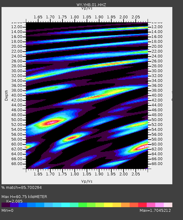
| Estimated Moho Depth: |
60.75 km |
| Estimated Crust Vp/Vs: |
2.09 |
| Assumed Crust Vp: |
6.35 km/s |
| Estimated Crust Vs: |
3.046 km/s |
| Estimated Crust Poisson's Ratio: |
0.35 |
|
| Radial Match: |
85.700294 % |
| Radial Bump: |
390 |
| Transverse Match: |
69.48777 % |
| Transverse Bump: |
349 |
| SOD ConfigId: |
872571 |
| Insert Time: |
2015-04-16 04:36:38.805 +0000 |
| GWidth: |
2.5 |
| Max Bumps: |
400 |
| Tol: |
0.001 |
|

Signal To Noise
| Channel | StoN | STA | LTA |
| WY:YHB:01:HHZ:20150402T04:21:27.814983Z | 17.61628 | 6.1083156E-8 | 3.4674263E-9 |
| WY:YHB:01:HHN:20150402T04:21:27.814983Z | 2.1487186 | 9.357156E-9 | 4.3547606E-9 |
| WY:YHB:01:HHE:20150402T04:21:27.814983Z | 6.8258796 | 1.8496873E-8 | 2.7098155E-9 |
| Arrivals |
| Ps | 11 SECOND |
| PpPs | 29 SECOND |
| PsPs/PpSs | 40 SECOND |


