You are here: Home > Network List > CI - Caltech Regional Seismic Network Stations List
> Station GLA Glamis, California, USA > Earthquake Result Viewer
GLA Glamis, California, USA - Earthquake Result Viewer
| Earthquake location: |
Costa Rica |
| Earthquake latitude/longitude: |
9.0/-84.2 |
| Earthquake time(UTC): |
1999/08/20 (232) 10:02:21 GMT |
| Earthquake Depth: |
20 km |
| Earthquake Magnitude: |
6.1 MB, 6.9 MS, 7.0 MW, 6.1 ML |
| Earthquake Catalog/Contributor: |
WHDF/NEIC |
|
| Network: |
CI Caltech Regional Seismic Network |
| Station: |
GLA Glamis, California, USA |
| Lat/Lon: |
33.05 N/114.83 W |
| Elevation: |
627 m |
|
| Distance: |
37.0 deg |
| Az: |
314.662 deg |
| Baz: |
123.227 deg |
| Ray Param: |
0.076332234 |
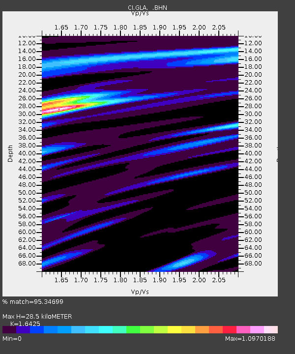
| Estimated Moho Depth: |
28.5 km |
| Estimated Crust Vp/Vs: |
1.64 |
| Assumed Crust Vp: |
6.155 km/s |
| Estimated Crust Vs: |
3.747 km/s |
| Estimated Crust Poisson's Ratio: |
0.21 |
|
| Radial Match: |
95.34699 % |
| Radial Bump: |
282 |
| Transverse Match: |
87.56124 % |
| Transverse Bump: |
400 |
| SOD ConfigId: |
3787 |
| Insert Time: |
2010-02-25 21:48:47.001 +0000 |
| GWidth: |
2.5 |
| Max Bumps: |
400 |
| Tol: |
0.001 |
|
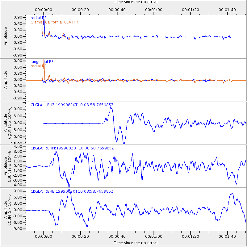
Signal To Noise
| Channel | StoN | STA | LTA |
| CI:GLA: :BHN:19990820T10:08:58.765985Z | 3.8344762 | 4.1251056E-7 | 1.07579375E-7 |
| CI:GLA: :BHE:19990820T10:08:58.765985Z | 6.9026985 | 9.037328E-7 | 1.3092458E-7 |
| CI:GLA: :BHZ:19990820T10:08:58.765985Z | 19.384115 | 1.5698548E-6 | 8.0986666E-8 |
| Arrivals |
| Ps | 3.2 SECOND |
| PpPs | 11 SECOND |
| PsPs/PpSs | 15 SECOND |


