You are here: Home > Network List > CI - Caltech Regional Seismic Network Stations List
> Station GLA Glamis, California, USA > Earthquake Result Viewer
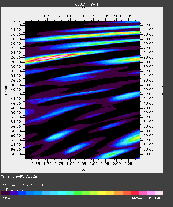
GLA Glamis, California, USA - Earthquake Result Viewer
| Earthquake location: |
Kermadec Islands, New Zealand |
| Earthquake latitude/longitude: |
-30.3/-178.0 |
| Earthquake time(UTC): |
1999/07/28 (209) 10:08:20 GMT |
| Earthquake Depth: |
25 km |
| Earthquake Magnitude: |
6.1 MB, 6.0 MS, 6.3 MW, 6.1 ME |
| Earthquake Catalog/Contributor: |
WHDF/NEIC |
|
| Network: |
CI Caltech Regional Seismic Network |
| Station: |
GLA Glamis, California, USA |
| Lat/Lon: |
33.05 N/114.83 W |
| Elevation: |
627 m |
|
| Distance: |
86.8 deg |
| Az: |
48.651 deg |
| Baz: |
230.64 deg |
| Ray Param: |
0.04373932 |
| Estimated Moho Depth: |
25.75 km |
| Estimated Crust Vp/Vs: |
1.72 |
| Assumed Crust Vp: |
6.155 km/s |
| Estimated Crust Vs: |
3.583 km/s |
| Estimated Crust Poisson's Ratio: |
0.24 |
|
| Radial Match: |
95.71228 % |
| Radial Bump: |
400 |
| Transverse Match: |
86.60445 % |
| Transverse Bump: |
400 |
| SOD ConfigId: |
3787 |
| Insert Time: |
2010-02-25 21:48:50.725 +0000 |
| GWidth: |
2.5 |
| Max Bumps: |
400 |
| Tol: |
0.001 |
|

Signal To Noise
| Channel | StoN | STA | LTA |
| CI:GLA: :BHN:19990728T10:20:31.417017Z | 2.5257008 | 1.593312E-7 | 6.308395E-8 |
| CI:GLA: :BHE:19990728T10:20:31.417017Z | 1.9191487 | 1.220201E-7 | 6.358032E-8 |
| CI:GLA: :BHZ:19990728T10:20:31.417017Z | 8.159336 | 6.5831347E-7 | 8.068224E-8 |
| Arrivals |
| Ps | 3.1 SECOND |
| PpPs | 11 SECOND |
| PsPs/PpSs | 14 SECOND |


