You are here: Home > Network List > CI - Caltech Regional Seismic Network Stations List
> Station GLA Glamis, California, USA > Earthquake Result Viewer
GLA Glamis, California, USA - Earthquake Result Viewer
| Earthquake location: |
Kermadec Islands Region |
| Earthquake latitude/longitude: |
-28.6/-177.6 |
| Earthquake time(UTC): |
1999/07/19 (200) 02:17:03 GMT |
| Earthquake Depth: |
39 km |
| Earthquake Magnitude: |
6.3 MB, 6.2 MS, 6.4 MW, 6.3 ME |
| Earthquake Catalog/Contributor: |
WHDF/NEIC |
|
| Network: |
CI Caltech Regional Seismic Network |
| Station: |
GLA Glamis, California, USA |
| Lat/Lon: |
33.05 N/114.83 W |
| Elevation: |
627 m |
|
| Distance: |
85.5 deg |
| Az: |
48.52 deg |
| Baz: |
231.646 deg |
| Ray Param: |
0.04468292 |
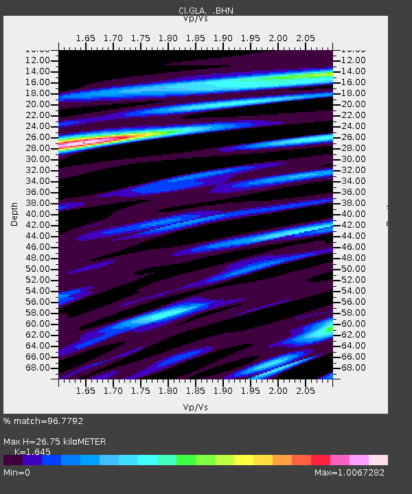
| Estimated Moho Depth: |
26.75 km |
| Estimated Crust Vp/Vs: |
1.64 |
| Assumed Crust Vp: |
6.155 km/s |
| Estimated Crust Vs: |
3.741 km/s |
| Estimated Crust Poisson's Ratio: |
0.21 |
|
| Radial Match: |
96.7792 % |
| Radial Bump: |
366 |
| Transverse Match: |
95.342384 % |
| Transverse Bump: |
400 |
| SOD ConfigId: |
3787 |
| Insert Time: |
2010-02-25 21:48:52.227 +0000 |
| GWidth: |
2.5 |
| Max Bumps: |
400 |
| Tol: |
0.001 |
|
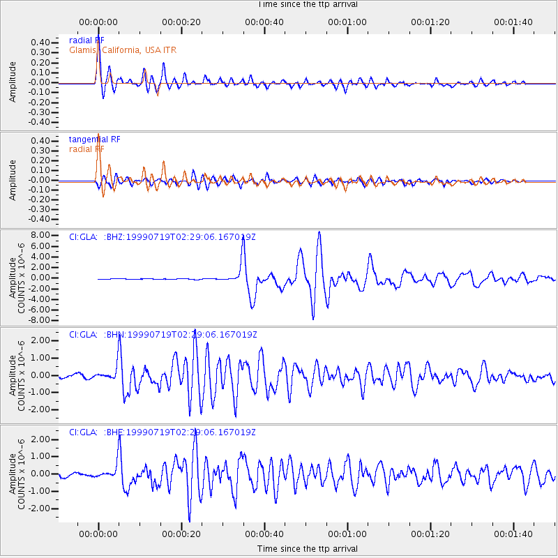
Signal To Noise
| Channel | StoN | STA | LTA |
| CI:GLA: :BHN:19990719T02:29:06.167019Z | 6.421102 | 4.3989448E-7 | 6.850763E-8 |
| CI:GLA: :BHE:19990719T02:29:06.167019Z | 5.237387 | 4.3513677E-7 | 8.3082796E-8 |
| CI:GLA: :BHZ:19990719T02:29:06.167019Z | 27.667336 | 1.9840786E-6 | 7.171196E-8 |
| Arrivals |
| Ps | 2.9 SECOND |
| PpPs | 11 SECOND |
| PsPs/PpSs | 14 SECOND |


