You are here: Home > Network List > TA - USArray Transportable Network (new EarthScope stations) Stations List
> Station Z41A Richland Creek Farm, El Dorado, AR, USA > Earthquake Result Viewer
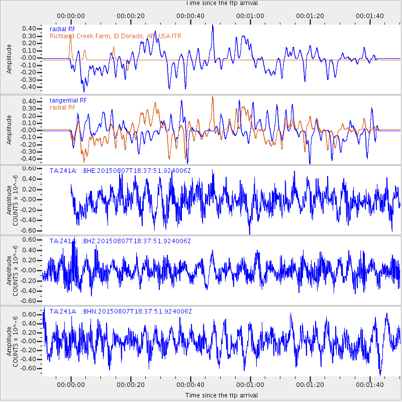
Z41A Richland Creek Farm, El Dorado, AR, USA - Earthquake Result Viewer
*The percent match for this event was below the threshold and hence no stack was calculated.
| Earthquake location: |
Tonga Islands |
| Earthquake latitude/longitude: |
-16.4/-173.0 |
| Earthquake time(UTC): |
2015/08/07 (219) 18:25:22 GMT |
| Earthquake Depth: |
32 km |
| Earthquake Magnitude: |
5.0 mb |
| Earthquake Catalog/Contributor: |
ISC/ISC |
|
| Network: |
TA USArray Transportable Network (new EarthScope stations) |
| Station: |
Z41A Richland Creek Farm, El Dorado, AR, USA |
| Lat/Lon: |
33.26 N/92.80 W |
| Elevation: |
62 m |
|
| Distance: |
90.9 deg |
| Az: |
55.673 deg |
| Baz: |
251.107 deg |
| Ray Param: |
$rayparam |
*The percent match for this event was below the threshold and hence was not used in the summary stack. |
|
| Radial Match: |
39.165382 % |
| Radial Bump: |
400 |
| Transverse Match: |
44.921856 % |
| Transverse Bump: |
400 |
| SOD ConfigId: |
7422571 |
| Insert Time: |
2019-04-20 05:33:50.008 +0000 |
| GWidth: |
2.5 |
| Max Bumps: |
400 |
| Tol: |
0.001 |
|
Signal To Noise
| Channel | StoN | STA | LTA |
| TA:Z41A: :BHZ:20150807T18:37:51.924006Z | 2.3814936 | 2.6104183E-7 | 1.0961265E-7 |
| TA:Z41A: :BHN:20150807T18:37:51.924006Z | 0.86721396 | 2.2356309E-7 | 2.5779462E-7 |
| TA:Z41A: :BHE:20150807T18:37:51.924006Z | 1.4277266 | 2.7342492E-7 | 1.9151071E-7 |
| Arrivals |
| Ps | |
| PpPs | |
| PsPs/PpSs | |


