You are here: Home > Network List > TA - USArray Transportable Network (new EarthScope stations) Stations List
> Station X43A Marvell, AR, USA > Earthquake Result Viewer
X43A Marvell, AR, USA - Earthquake Result Viewer
| Earthquake location: |
Kuril Islands |
| Earthquake latitude/longitude: |
45.2/150.0 |
| Earthquake time(UTC): |
2015/08/07 (219) 20:43:17 GMT |
| Earthquake Depth: |
59 km |
| Earthquake Magnitude: |
4.7 mb |
| Earthquake Catalog/Contributor: |
ISC/ISC |
|
| Network: |
TA USArray Transportable Network (new EarthScope stations) |
| Station: |
X43A Marvell, AR, USA |
| Lat/Lon: |
34.52 N/90.88 W |
| Elevation: |
53 m |
|
| Distance: |
83.4 deg |
| Az: |
46.588 deg |
| Baz: |
321.538 deg |
| Ray Param: |
0.046113215 |
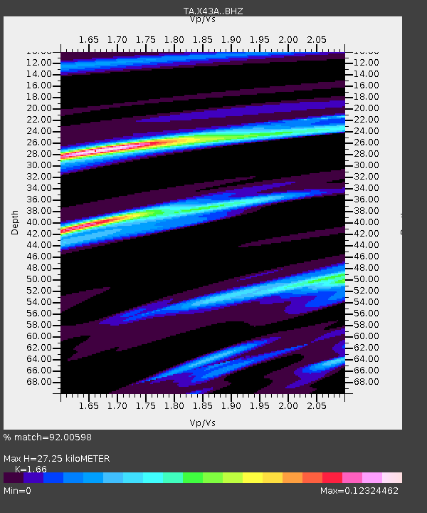
| Estimated Moho Depth: |
27.25 km |
| Estimated Crust Vp/Vs: |
1.66 |
| Assumed Crust Vp: |
6.273 km/s |
| Estimated Crust Vs: |
3.779 km/s |
| Estimated Crust Poisson's Ratio: |
0.22 |
|
| Radial Match: |
92.00598 % |
| Radial Bump: |
400 |
| Transverse Match: |
87.45733 % |
| Transverse Bump: |
400 |
| SOD ConfigId: |
7422571 |
| Insert Time: |
2019-04-20 05:41:41.012 +0000 |
| GWidth: |
2.5 |
| Max Bumps: |
400 |
| Tol: |
0.001 |
|
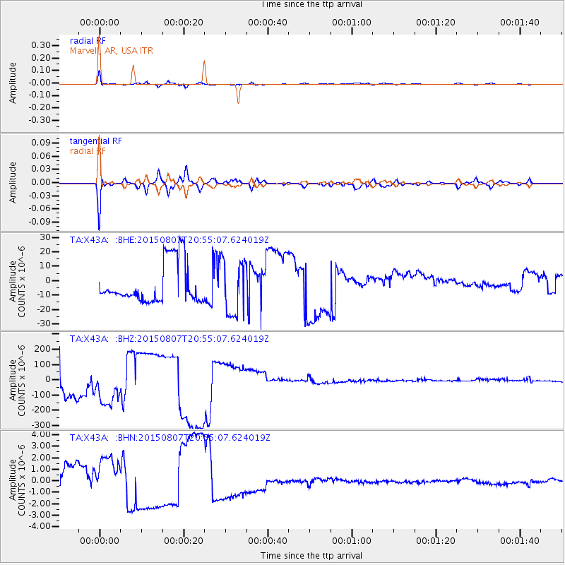
Signal To Noise
| Channel | StoN | STA | LTA |
| TA:X43A: :BHZ:20150807T20:55:07.624019Z | 0.9475685 | 1.2535656E-4 | 1.3229287E-4 |
| TA:X43A: :BHN:20150807T20:55:07.624019Z | 0.94740456 | 1.6886427E-6 | 1.782388E-6 |
| TA:X43A: :BHE:20150807T20:55:07.624019Z | 1.3136519 | 1.866442E-5 | 1.4208041E-5 |
| Arrivals |
| Ps | 2.9 SECOND |
| PpPs | 11 SECOND |
| PsPs/PpSs | 14 SECOND |


