You are here: Home > Network List > AG - Arkansas Seismic Network Stations List
> Station WHAR Woolly Hollow State Park,AR > Earthquake Result Viewer
WHAR Woolly Hollow State Park,AR - Earthquake Result Viewer
| Earthquake location: |
Tonga Islands |
| Earthquake latitude/longitude: |
-15.2/-173.2 |
| Earthquake time(UTC): |
2015/04/07 (097) 00:46:18 GMT |
| Earthquake Depth: |
10 km |
| Earthquake Magnitude: |
5.8 MB |
| Earthquake Catalog/Contributor: |
NEIC PDE/NEIC ALERT |
|
| Network: |
AG Arkansas Seismic Network |
| Station: |
WHAR Woolly Hollow State Park,AR |
| Lat/Lon: |
35.29 N/92.29 W |
| Elevation: |
184 m |
|
| Distance: |
91.5 deg |
| Az: |
53.911 deg |
| Baz: |
252.499 deg |
| Ray Param: |
0.041600928 |
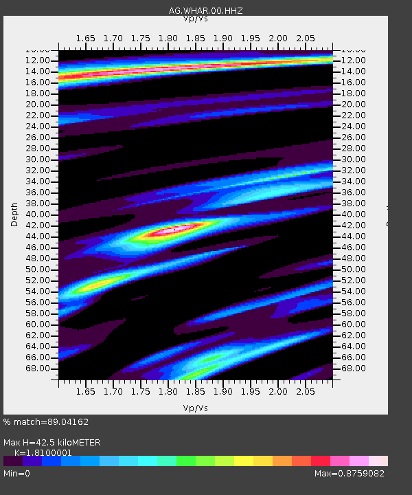
| Estimated Moho Depth: |
42.5 km |
| Estimated Crust Vp/Vs: |
1.81 |
| Assumed Crust Vp: |
6.498 km/s |
| Estimated Crust Vs: |
3.59 km/s |
| Estimated Crust Poisson's Ratio: |
0.28 |
|
| Radial Match: |
89.04162 % |
| Radial Bump: |
265 |
| Transverse Match: |
77.94115 % |
| Transverse Bump: |
233 |
| SOD ConfigId: |
872571 |
| Insert Time: |
2015-04-21 00:59:32.307 +0000 |
| GWidth: |
2.5 |
| Max Bumps: |
400 |
| Tol: |
0.001 |
|

Signal To Noise
| Channel | StoN | STA | LTA |
| AG:WHAR:00:HHZ:20150407T00:58:53.034985Z | 19.188133 | 1.7199028E-6 | 8.9633666E-8 |
| AG:WHAR:00:HHN:20150407T00:58:53.034985Z | 0.7224054 | 1.0178619E-7 | 1.40899E-7 |
| AG:WHAR:00:HHE:20150407T00:58:53.034985Z | 3.6885638 | 4.4098746E-7 | 1.1955534E-7 |
| Arrivals |
| Ps | 5.4 SECOND |
| PpPs | 18 SECOND |
| PsPs/PpSs | 23 SECOND |


