You are here: Home > Network List > GS - US Geological Survey Networks Stations List
> Station OK029 Liberty Lake, Oklahoma, USA > Earthquake Result Viewer
OK029 Liberty Lake, Oklahoma, USA - Earthquake Result Viewer
| Earthquake location: |
Tonga Islands |
| Earthquake latitude/longitude: |
-15.2/-173.2 |
| Earthquake time(UTC): |
2015/04/07 (097) 00:46:18 GMT |
| Earthquake Depth: |
10 km |
| Earthquake Magnitude: |
5.8 MB |
| Earthquake Catalog/Contributor: |
NEIC PDE/NEIC ALERT |
|
| Network: |
GS US Geological Survey Networks |
| Station: |
OK029 Liberty Lake, Oklahoma, USA |
| Lat/Lon: |
35.80 N/97.45 W |
| Elevation: |
333 m |
|
| Distance: |
87.6 deg |
| Az: |
52.062 deg |
| Baz: |
249.493 deg |
| Ray Param: |
0.04318347 |
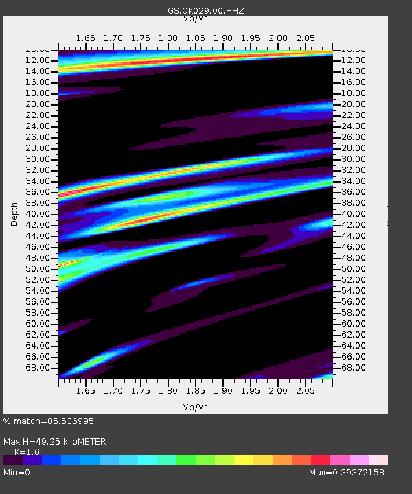
| Estimated Moho Depth: |
49.25 km |
| Estimated Crust Vp/Vs: |
1.60 |
| Assumed Crust Vp: |
6.426 km/s |
| Estimated Crust Vs: |
4.016 km/s |
| Estimated Crust Poisson's Ratio: |
0.18 |
|
| Radial Match: |
85.536995 % |
| Radial Bump: |
312 |
| Transverse Match: |
70.32134 % |
| Transverse Bump: |
400 |
| SOD ConfigId: |
872571 |
| Insert Time: |
2015-04-21 01:01:14.359 +0000 |
| GWidth: |
2.5 |
| Max Bumps: |
400 |
| Tol: |
0.001 |
|

Signal To Noise
| Channel | StoN | STA | LTA |
| GS:OK029:00:HHZ:20150407T00:58:35.188977Z | 9.185974 | 1.908027E-6 | 2.0771088E-7 |
| GS:OK029:00:HH1:20150407T00:58:35.188977Z | 2.722555 | 4.270474E-7 | 1.5685539E-7 |
| GS:OK029:00:HH2:20150407T00:58:35.188977Z | 2.7042093 | 3.9825565E-7 | 1.472725E-7 |
| Arrivals |
| Ps | 4.7 SECOND |
| PpPs | 19 SECOND |
| PsPs/PpSs | 24 SECOND |


