You are here: Home > Network List > GS - US Geological Survey Networks Stations List
> Station OK032 Salt Plains WLR near Rte 11, Oklahoma, USA > Earthquake Result Viewer
OK032 Salt Plains WLR near Rte 11, Oklahoma, USA - Earthquake Result Viewer
| Earthquake location: |
Tonga Islands |
| Earthquake latitude/longitude: |
-15.2/-173.2 |
| Earthquake time(UTC): |
2015/04/07 (097) 00:46:18 GMT |
| Earthquake Depth: |
10 km |
| Earthquake Magnitude: |
5.8 MB |
| Earthquake Catalog/Contributor: |
NEIC PDE/NEIC ALERT |
|
| Network: |
GS US Geological Survey Networks |
| Station: |
OK032 Salt Plains WLR near Rte 11, Oklahoma, USA |
| Lat/Lon: |
36.80 N/98.21 W |
| Elevation: |
345 m |
|
| Distance: |
87.4 deg |
| Az: |
50.905 deg |
| Baz: |
248.998 deg |
| Ray Param: |
0.043337725 |
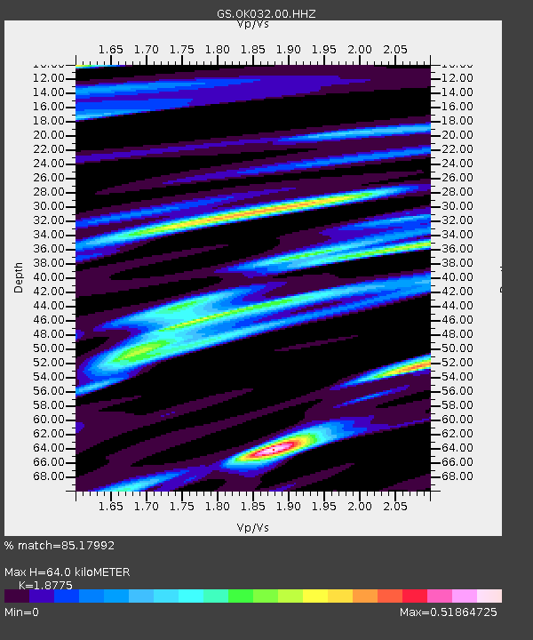
| Estimated Moho Depth: |
64.0 km |
| Estimated Crust Vp/Vs: |
1.88 |
| Assumed Crust Vp: |
6.426 km/s |
| Estimated Crust Vs: |
3.423 km/s |
| Estimated Crust Poisson's Ratio: |
0.30 |
|
| Radial Match: |
85.17992 % |
| Radial Bump: |
400 |
| Transverse Match: |
74.07045 % |
| Transverse Bump: |
400 |
| SOD ConfigId: |
872571 |
| Insert Time: |
2015-04-21 01:02:22.223 +0000 |
| GWidth: |
2.5 |
| Max Bumps: |
400 |
| Tol: |
0.001 |
|

Signal To Noise
| Channel | StoN | STA | LTA |
| GS:OK032:00:HHZ:20150407T00:58:34.169019Z | 21.392223 | 2.3363482E-6 | 1.0921483E-7 |
| GS:OK032:00:HH1:20150407T00:58:34.169019Z | 2.630571 | 4.6287803E-7 | 1.7596105E-7 |
| GS:OK032:00:HH2:20150407T00:58:34.169019Z | 3.8577883 | 5.871627E-7 | 1.5220189E-7 |
| Arrivals |
| Ps | 8.9 SECOND |
| PpPs | 28 SECOND |
| PsPs/PpSs | 37 SECOND |


