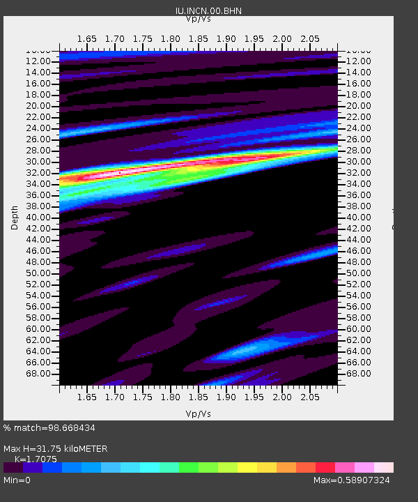
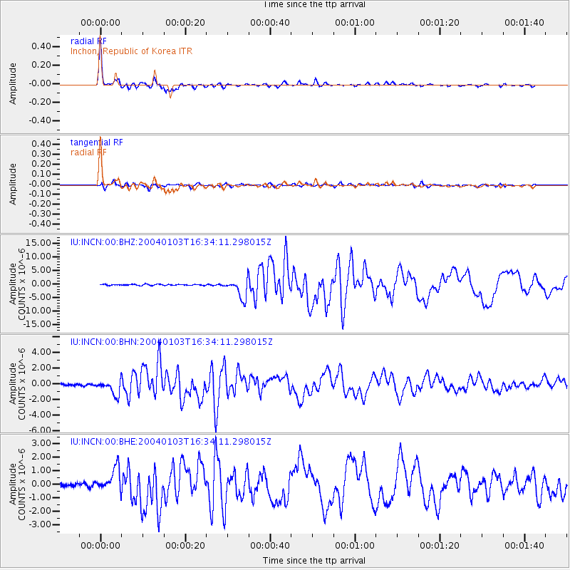
INCN Inchon, Republic of Korea - Earthquake Result Viewer

Earthquake location: Southeast Of Loyalty Islands
Earthquake latitude/longitude: -22.3/169.7
Earthquake time(UTC): 2004/01/03 (003) 16:23:21 GMT
Earthquake Depth: 22 km
Earthquake Magnitude: 6.4 MB, 7.1 MS, 7.1 MW, 6.8 MW
Earthquake Catalog/Contributor: WHDF/NEIC
Network: IU Global Seismograph Network (GSN - IRIS/USGS)
Station: INCN Inchon, Republic of Korea
Lat/Lon: 37.48 N/126.63 E
Elevation: 420 m
Distance: 71.9 deg
Az: 325.163 deg
Baz: 138.298 deg
Ray Param: 0.053983226
Estimated Moho Depth: 31.75 km
Estimated Crust Vp/Vs: 1.71
Assumed Crust Vp: 6.459 km/s
Estimated Crust Vs: 3.783 km/s
Estimated Crust Poisson's Ratio: 0.24
Radial Match: 98.668434 %
Radial Bump: 291
Transverse Match: 90.972206 %
Transverse Bump: 400
SOD ConfigId: 7314
Insert Time: 2010-03-04 14:59:41.697 +0000
GWidth: 2.5
Max Bumps: 400
Tol: 0.001

Signal To Noise

ChannelStoNSTALTA
IU:INCN:00:BHN:20040103T16:34:11.298015Z8.1404039.748237E-71.1975129E-7
IU:INCN:00:BHE:20040103T16:34:11.298015Z6.9205989.06025E-71.3091714E-7
IU:INCN:00:BHZ:20040103T16:34:11.298015Z18.9669823.5777969E-61.886329E-7
Arrivals
Ps3.6 SECOND
PpPs13 SECOND
PsPs/PpSs16 SECOND