You are here: Home > Network List > GS - US Geological Survey Networks Stations List
> Station KAN10 Keim Farm > Earthquake Result Viewer
KAN10 Keim Farm - Earthquake Result Viewer
*The percent match for this event was below the threshold and hence no stack was calculated.
| Earthquake location: |
Kuril Islands |
| Earthquake latitude/longitude: |
48.2/153.6 |
| Earthquake time(UTC): |
2015/08/08 (220) 22:47:37 GMT |
| Earthquake Depth: |
150 km |
| Earthquake Magnitude: |
4.2 mb |
| Earthquake Catalog/Contributor: |
ISC/ISC |
|
| Network: |
GS US Geological Survey Networks |
| Station: |
KAN10 Keim Farm |
| Lat/Lon: |
37.12 N/98.10 W |
| Elevation: |
417 m |
|
| Distance: |
73.8 deg |
| Az: |
52.218 deg |
| Baz: |
318.592 deg |
| Ray Param: |
$rayparam |
*The percent match for this event was below the threshold and hence was not used in the summary stack. |
|
| Radial Match: |
75.21608 % |
| Radial Bump: |
400 |
| Transverse Match: |
75.39466 % |
| Transverse Bump: |
400 |
| SOD ConfigId: |
7422571 |
| Insert Time: |
2019-04-20 06:09:41.188 +0000 |
| GWidth: |
2.5 |
| Max Bumps: |
400 |
| Tol: |
0.001 |
|
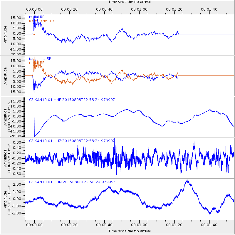
Signal To Noise
| Channel | StoN | STA | LTA |
| GS:KAN10:01:HHZ:20150808T22:58:24.97999Z | 0.4612523 | 9.174687E-8 | 1.9890821E-7 |
| GS:KAN10:01:HHN:20150808T22:58:24.97999Z | 0.50451887 | 8.938705E-7 | 1.7717286E-6 |
| GS:KAN10:01:HHE:20150808T22:58:24.97999Z | 0.82564926 | 4.9921346E-6 | 6.046314E-6 |
| Arrivals |
| Ps | |
| PpPs | |
| PsPs/PpSs | |


