You are here: Home > Network List > TA - USArray Transportable Network (new EarthScope stations) Stations List
> Station J01E Myrtle Point, OR, USA > Earthquake Result Viewer
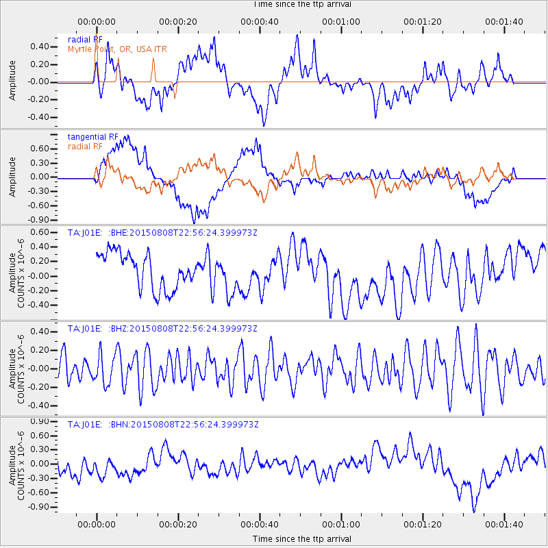
J01E Myrtle Point, OR, USA - Earthquake Result Viewer
*The percent match for this event was below the threshold and hence no stack was calculated.
| Earthquake location: |
Kuril Islands |
| Earthquake latitude/longitude: |
48.2/153.6 |
| Earthquake time(UTC): |
2015/08/08 (220) 22:47:37 GMT |
| Earthquake Depth: |
150 km |
| Earthquake Magnitude: |
4.2 mb |
| Earthquake Catalog/Contributor: |
ISC/ISC |
|
| Network: |
TA USArray Transportable Network (new EarthScope stations) |
| Station: |
J01E Myrtle Point, OR, USA |
| Lat/Lon: |
43.16 N/123.93 W |
| Elevation: |
128 m |
|
| Distance: |
55.2 deg |
| Az: |
62.081 deg |
| Baz: |
306.125 deg |
| Ray Param: |
$rayparam |
*The percent match for this event was below the threshold and hence was not used in the summary stack. |
|
| Radial Match: |
54.000397 % |
| Radial Bump: |
400 |
| Transverse Match: |
45.808994 % |
| Transverse Bump: |
400 |
| SOD ConfigId: |
7422571 |
| Insert Time: |
2019-04-20 06:13:09.287 +0000 |
| GWidth: |
2.5 |
| Max Bumps: |
400 |
| Tol: |
0.001 |
|
Signal To Noise
| Channel | StoN | STA | LTA |
| TA:J01E: :BHZ:20150808T22:56:24.399973Z | 0.82176465 | 1.6327957E-7 | 1.9869383E-7 |
| TA:J01E: :BHN:20150808T22:56:24.399973Z | 0.99963653 | 2.3287632E-7 | 2.3296099E-7 |
| TA:J01E: :BHE:20150808T22:56:24.399973Z | 1.0503219 | 2.4891955E-7 | 2.3699357E-7 |
| Arrivals |
| Ps | |
| PpPs | |
| PsPs/PpSs | |


